
Vaizdas:Weimar Republic states map.svg

Rinkmenos SVG peržiūros PNG dydisː 715 × 599 taškų. Kitos 6 rezoliucijos: 286 × 240 taškų | 573 × 480 taškų | 916 × 768 taškų | 1 222 × 1 024 taškų | 2 444 × 2 048 taškų | 976 × 818 taškų.
Didesnės raiškos iliustracija (SVG rinkmena, formaliai 976 × 818 taškų, rinkmenos dydis: 949 KiB)
| Ši byla yra iš bendros Wikimedia Commons nemokamų resursų duomenų bazės, palaikomos Wikimedia Foundation organizacijos. Norėdami sužinoti licencijavimo smulkmenas, žiūrėkite paveikslėlio aprašymą |  |
Į paveikslėlio aprašymą |
Aprašymas
| Aprašymas |
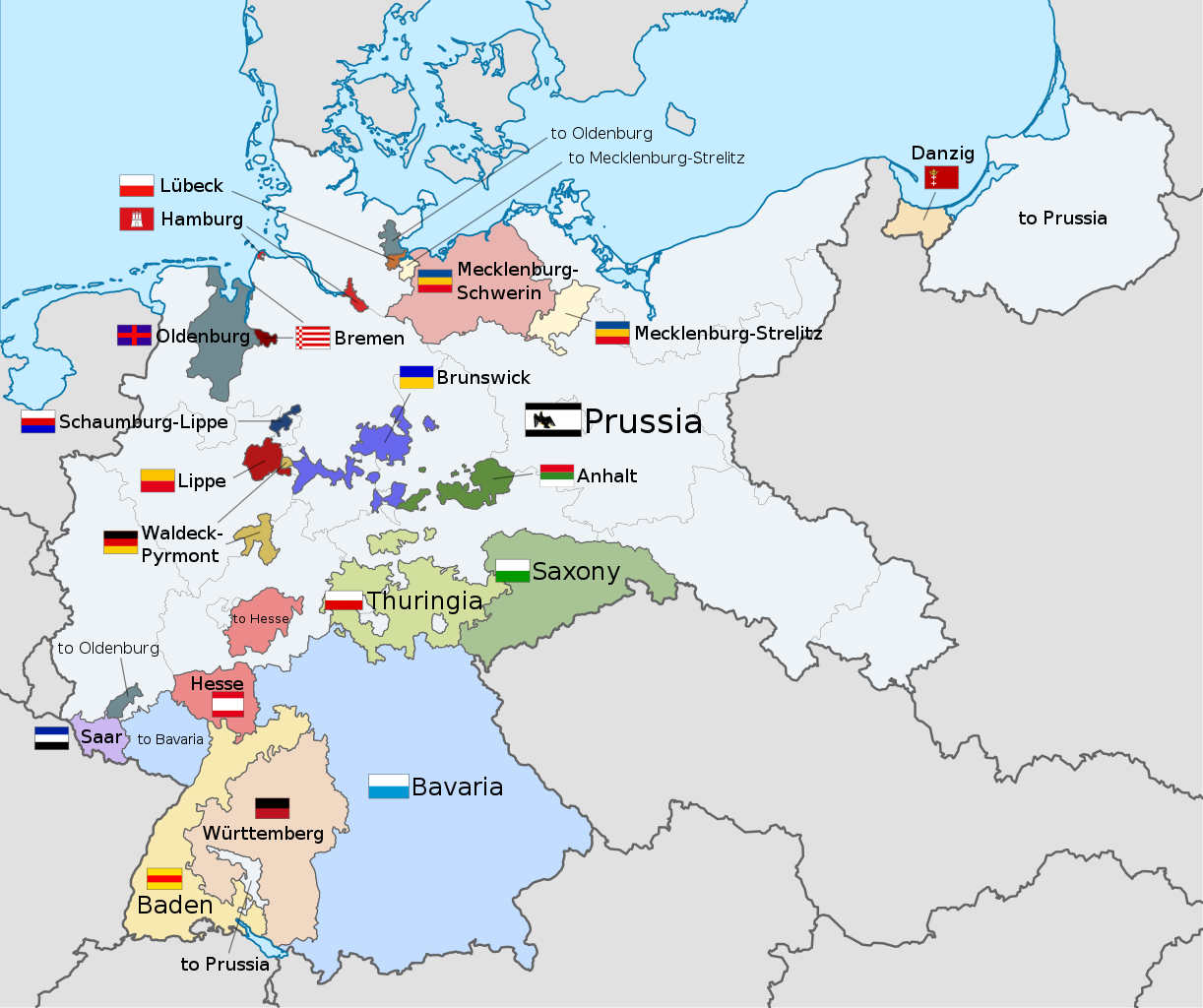
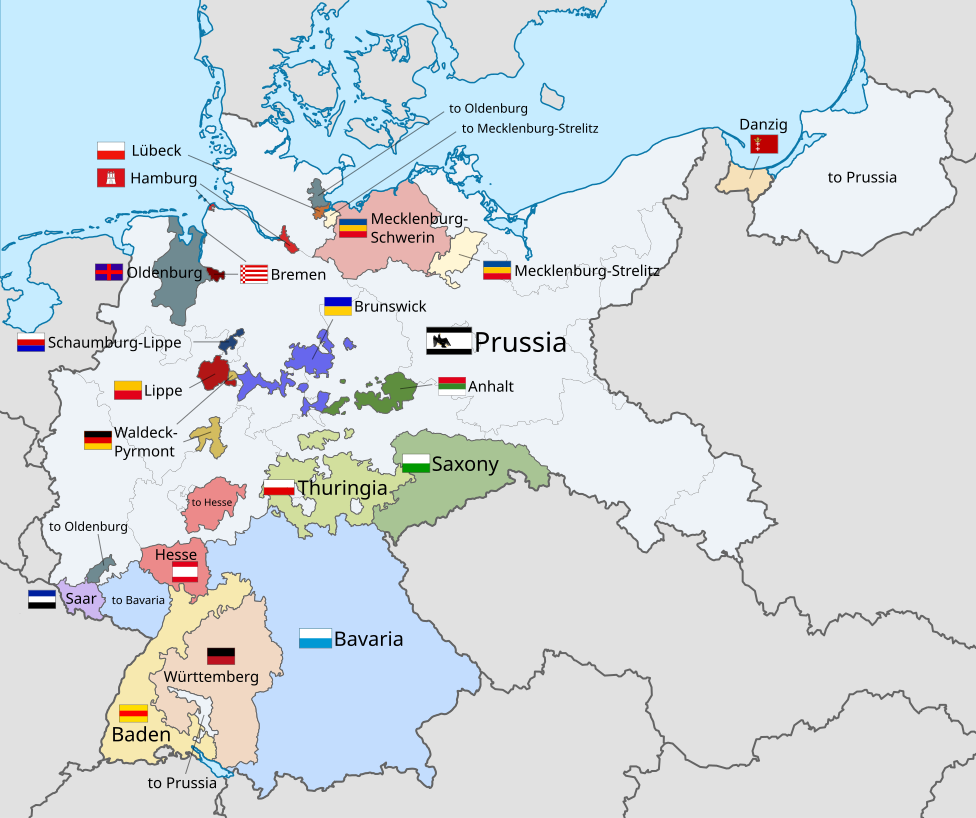
English: A map of the states of the Weimar Republic, showing their location, flags and names in English. |
| Data | |
| Šaltinis |
Šis failas buvo kilęs iš: Weimar Republic blank map.svg: This vector image includes elements that have been taken or adapted from this file: This vector image includes elements that have been taken or adapted from this file: This vector image includes elements that have been taken or adapted from this file: This vector image includes elements that have been taken or adapted from this file: This vector image includes elements that have been taken or adapted from this file: This vector image includes elements that have been taken or adapted from this file: This vector image includes elements that have been taken or adapted from this file: This vector image includes elements that have been taken or adapted from this file: This vector image includes elements that have been taken or adapted from this file: This vector image includes elements that have been taken or adapted from this file: This vector image includes elements that have been taken or adapted from this file: This vector image includes elements that have been taken or adapted from this file: This vector image includes elements that have been taken or adapted from this file: This vector image includes elements that have been taken or adapted from this file: This vector image includes elements that have been taken or adapted from this file: This vector image includes elements that have been taken or adapted from this file: |
| Autorius |
|
| Kitos versijos |
|
| SVG genesis | Šis vektorinis paveikslėlis sukurtas su Inkscape. This flag uses embedded text that can be easily translated using a text editor. |


.svg)


.svg)
.svg)
.svg)
.svg)
Licencija
Aš, šio darbo autoriaus teisių savininkas, publikuoju jį su šia licencija:
Šiam failui taikoma Creative Commons Attribution-Share Alike 3.0 Unported licencija.
- Jūs galite:
- dalintis – kopijuoti, platinti bei persiųsti šį darbą
- pri(si)taikyti – adaptuoti darbą
- Su šiomis sąlygomis:
- autoriaus nurodymas – Turite pateikti atitinkamą kreditą, pateikti nuorodą į licenciją ir nurodyti, ar buvo atlikti pakeitimai. Tai galite padaryti bet kokiu būdu, bet ne taip, kad licencijos išdavėjas patvirtintų jus ar jūsų naudojimą.
- dalinkis panašiai – Jei perdirbsite, redaguosite ar atkursite šį darbą, jį galėsite platinti tik su tokia pačia ar panašia į šią licencija.
Code for clickable map

Rinkmenos istorija
Paspauskite ant datos/laiko, kad pamatytumėte rinkmeną tokią, kokia ji buvo tuo metu.
| Data/Laikas | Miniatiūra | Matmenys | Naudotojas | Paaiškinimas | |
|---|---|---|---|---|---|
| dabartinis | 01:22, 18 gruodžio 2021 | | 976 × 818 (949 KiB) | Alphathon | Corrections to Anhalt and Brunswick |
| 06:28, 5 lapkričio 2015 |  | 976 × 818 (981 KiB) | Alphathon | {{Information |Description={{en|A map of the states of the en:Weimar Republic, showing their location, flags and names in English.}}{{Valid SVG}} |Source={{Derived from|File:Weimar Republic blank map.svg|display=50}} {{AttribSVG|Flag of Prussia (... |
Paveikslėlio naudojimas
Paveikslėlis yra naudojamas šiuose puslapiuose:
Visuotinis rinkmenos naudojimas
Ši rinkmena naudojama šiose viki svetainėse:
- Naudojama ar.wikipedia.org
- Naudojama ast.wikipedia.org
- Naudojama ca.wikipedia.org
- Naudojama en.wikipedia.org
- Gleichschaltung
- Weimar Republic
- States of Germany
- Prussia
- Reichsrat (Germany)
- Reichsstatthalter
- States of the Weimar Republic
- Template:Weimar Republic States
- User:Falcaorib
- Provisional Law and Second Law on the Coordination of the States with the Reich
- Nazi Party election results
- Law on the Reconstruction of the Reich
- Naudojama fa.wikipedia.org
- Naudojama fy.wikipedia.org
- Naudojama gd.wikipedia.org
- Naudojama hy.wikipedia.org
- Naudojama id.wikipedia.org
- Naudojama it.wikipedia.org
- Naudojama kk.wikipedia.org
- Naudojama ms.wikipedia.org
- Naudojama pt.wikipedia.org
- Naudojama simple.wikipedia.org
- Naudojama tr.wikipedia.org
- Naudojama ur.wikipedia.org
- Naudojama zh.wikipedia.org