
Vaizdas:The Man in the High Castle Plausible World Map.png
Šios peržiūros dydis: 800 × 579 taškų. Kitos 5 rezoliucijos: 320 × 232 taškų | 640 × 463 taškų | 1 024 × 741 taškų | 1 280 × 926 taškų | 1 577 × 1 141 taškų.
Didesnės raiškos iliustracija (1 577 × 1 141 taškų, rinkmenos dydis: 400 KiB, MIME tipas: image/png)
| Ši byla yra iš bendros Wikimedia Commons nemokamų resursų duomenų bazės, palaikomos Wikimedia Foundation organizacijos. Norėdami sužinoti licencijavimo smulkmenas, žiūrėkite paveikslėlio aprašymą |  |
Į paveikslėlio aprašymą |

|
This map, as well as other fictitious maps, is fictitious or too incorrect (i.e. due to anachronism) to be used in real-life contexts (contemporary or historic). It may have some visual elements that are similar to official maps such as colors or certain layout features, but they are NOT official and don't have any official recognition. |
[[Category:]]
Aprašymas
| Aprašymas |
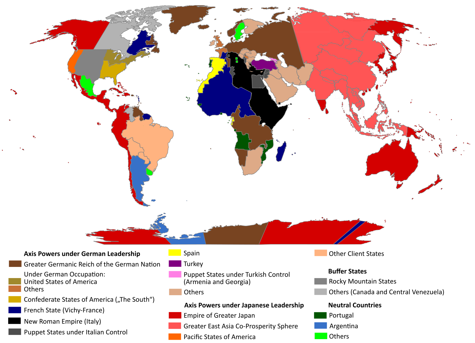
English: "The Man in the High Castle" is an alternate history novel by Philip K. Dick. It is set in a world in which the Axis powers have won World War II. This map is inspired by Dick's story and shows a plausible division of the world between Nazi Germany (dark brown), Imperial Japan (dark red) and their respective allies. However, the map is much more precise than the book describes.
https://web.archive.org/web/20191202005150/http://www.high-castle-world-map.com:80/ |
| Data | |
| Šaltinis | Mano darbas |
| Autorius | RobintheHighCastle |
| Leidimas (Šios rinkmenos panaudojimas kitur) |
Licencija
Aš, šio darbo autoriaus teisių savininkas, publikuoju jį su šia licencija:
This file is licensed under the Creative Commons Attribution-Share Alike 4.0 International license.
- Jūs galite:
- dalintis – kopijuoti, platinti bei persiųsti šį darbą
- pri(si)taikyti – adaptuoti darbą
- Su šiomis sąlygomis:
- autoriaus nurodymas – Turite pateikti atitinkamą kreditą, pateikti nuorodą į licenciją ir nurodyti, ar buvo atlikti pakeitimai. Tai galite padaryti bet kokiu būdu, bet ne taip, kad licencijos išdavėjas patvirtintų jus ar jūsų naudojimą.
- dalinkis panašiai – Jei perdirbsite, redaguosite ar atkursite šį darbą, jį galėsite platinti tik su tokia pačia ar panašia į šią licencija.
Rinkmenos istorija
Paspauskite ant datos/laiko, kad pamatytumėte rinkmeną tokią, kokia ji buvo tuo metu.
| Data/Laikas | Miniatiūra | Matmenys | Naudotojas | Paaiškinimas | |
|---|---|---|---|---|---|
| dabartinis | 17:55, 29 spalio 2021 | | 1 577 × 1 141 (400 KiB) | Saltner67 | Added the portoguese colonies Cabinda and Ajuda since they would still have existed in this world. |
| 11:05, 20 birželio 2021 |  | 1 613 × 1 143 (417 KiB) | Gernsback67 | Changed "Greater Asian Co-Prosperity Sphere" in "Greater East Asia Co-Prosperity Sphere", which is correct. | |
| 18:30, 16 spalio 2020 |  | 1 611 × 1 138 (418 KiB) | Saltner67 | Restored the latest version. Please do not revert any changes, which have been made to this file so far, without any communication with the author of the map. All changes made here have been initialized by the author and are a result of the same process which has led to the creation of the map in the first place. | |
| 11:25, 16 spalio 2020 |  | 1 621 × 1 137 (392 KiB) | Gooduserdude | RV Original research: this image is based on a source and should not be altered | |
| 17:15, 29 kovo 2020 |  | 1 611 × 1 138 (418 KiB) | Saltner67 | Improved the accuracy of borders of Mongolia and Manchukuo. | |
| 18:58, 27 kovo 2020 |  | 1 607 × 1 138 (418 KiB) | Saltner67 | Enlarged Manchukuo and added the puppet states of Yakutia and Krasnoyarsk/Irkutsk after more research on Kantokuen. | |
| 22:07, 12 kovo 2020 |  | 1 612 × 1 143 (411 KiB) | Saltner67 | Moved the Swiss Canton of Valais from Germany to Italy, as has been prepared in the plans for Operation Tannenbaum. | |
| 21:57, 8 vasario 2020 |  | 1 605 × 1 139 (411 KiB) | Saltner67 | Reinserted the territories of Tunisia,Greece, Crete and Cyprus after research on the Italian plannings and Greece in WWII. | |
| 16:21, 21 lapkričio 2019 |  | 1 611 × 1 133 (409 KiB) | Gernsback67 | Enlarged Mongolia again after more research on pan-mongolism. | |
| 18:13, 21 rugsėjo 2019 |  | 1 610 × 1 137 (408 KiB) | Saltner67 | unified Mongolia, enlarged Manchukuo and Thailand, re-inserted the real-life borders of Laos and Vietnam after research on Demchugdongrub, Kantokuen, Thailand and Indochina in WWII |
Paveikslėlio naudojimas
Paveikslėlis yra naudojamas šiuose puslapiuose:
Visuotinis rinkmenos naudojimas
Ši rinkmena naudojama šiose viki svetainėse:
- Naudojama ar.wikipedia.org
- Naudojama cs.wikipedia.org
- Naudojama da.wikipedia.org
- Naudojama de.wikipedia.org
- Naudojama en.wikipedia.org
- Naudojama en.wikiquote.org
- Naudojama es.wikipedia.org
- Naudojama gl.wikipedia.org
- Naudojama he.wikipedia.org
- Naudojama hu.wikipedia.org
- Naudojama it.wikipedia.org
- Naudojama ja.wikipedia.org
- Naudojama ko.wikipedia.org
- Naudojama nl.wikipedia.org
- Naudojama pl.wikipedia.org
- Naudojama pt.wikipedia.org
- Naudojama ro.wikipedia.org
- Naudojama ru.wikipedia.org
- Naudojama th.wikipedia.org
- Naudojama uk.wikipedia.org
- Naudojama zh-classical.wikipedia.org
- Naudojama zh.wikipedia.org