
Vaizdas:Sakura-jima from space.jpg

Didesnės raiškos iliustracija (3 000 × 3 716 taškų, rinkmenos dydis: 3,15 MiB, MIME tipas: image/jpeg)
| Ši byla yra iš bendros Wikimedia Commons nemokamų resursų duomenų bazės, palaikomos Wikimedia Foundation organizacijos. Norėdami sužinoti licencijavimo smulkmenas, žiūrėkite paveikslėlio aprašymą |  |
Į paveikslėlio aprašymą |
Aprašymas
| Aprašymas |
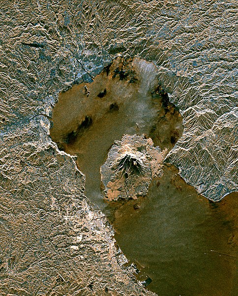
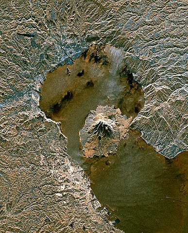
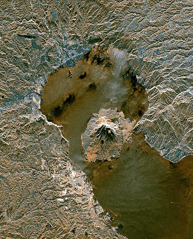
Sakurajima volcano and Aira Caldera from space. Original Caption Released with Image: The active volcano Sakura-Jima on the island of Kyushu, Japan is shown in the center of this radar image. The volcano occupies the peninsula in the center of Kagoshima Bay, which was formed by the explosion and collapse of an ancient predecessor of today's volcano. The volcano has been in near continuous eruption since 1955. Its explosions of ash and gas are closely monitored by local authorities due to the proximity of the city of Kagoshima across a narrow strait from the volcano's center, shown below and to the left of the central peninsula in this image. City residents have grown accustomed to clearing ash deposits from sidewalks, cars and buildings following Sakura-jima's eruptions. The volcano is one of 15 identified by scientists as potentially hazardous to local populations, as part of the international "Decade Volcano" program. The image was acquired by the Spaceborne Imaging Radar-C/X-Band Synthetic Aperture Radar (SIR-C/X-SAR) onboard the space shuttle Endeavour on October 9, 1994. SIR-C/X-SAR, a joint mission of the German, Italian and the United States space agencies, is part of NASA's Mission to Planet Earth. The image is centered at 31.6 degrees North latitude and 130.6 degrees East longitude. North is toward the upper left. The area shown measures 37.5 kilometers by 46.5 kilometers (23.3 miles by 28.8 miles). The colors in the image are assigned to different frequencies and polarizations of the radar as follows: red is L-band vertically transmitted, vertically received; green is the average of L-band vertically transmitted, vertically received and C-band vertically transmitted, vertically received; blue is C-band vertically transmitted, vertically received. |
|||||
| Data | ||||||
| Šaltinis | en:File:Sakura-jima from space.jpg | |||||
| Autorius | NASA/JPL-Caltech | |||||
| Leidimas (Šios rinkmenos panaudojimas kitur) |
|

Rinkmenos istorija
Paspauskite ant datos/laiko, kad pamatytumėte rinkmeną tokią, kokia ji buvo tuo metu.
| Data/Laikas | Miniatiūra | Matmenys | Naudotojas | Paaiškinimas | |
|---|---|---|---|---|---|
| dabartinis | 17:53, 17 liepos 2007 | | 3 000 × 3 716 (3,15 MiB) | GDK | |
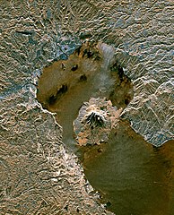
| 15:15, 16 spalio 2006 |  | 518 × 642 (114 KiB) | Pazuzu | Sakurajima volcano from space Copied from [http://en.wikipedia.org/wiki/Image:Sakura-jima_from_space.jpg en wiki] image description [http://photojournal.jpl.nasa.gov/catalog/PIA01777 here] larger version [http://photojournal.jpl.nasa.gov/jpeg/PIA01777. |
Paveikslėlio naudojimas
Paveikslėlis yra naudojamas šiuose puslapiuose:
Visuotinis rinkmenos naudojimas
Ši rinkmena naudojama šiose viki svetainėse:
- Naudojama ar.wikipedia.org
- Naudojama bn.wikipedia.org
- Naudojama cs.wikipedia.org
- Naudojama da.wikipedia.org
- Naudojama de.wikipedia.org
- Naudojama en.wikipedia.org
- Sakurajima
- Aira Caldera
- Kirishima-Kinkowan National Park
- Template:Infobox mountain/testcases
- Wikipedia:Featured picture candidates/April-2009
- Wikipedia:Featured picture candidates/Sakurajima
- Template:Infobox mountain/testcases2
- Template:Infobox mountain/test versus status quo ante
- User:Hike395/test mountain bot
- Naudojama es.wikipedia.org
- Naudojama eu.wikipedia.org
- Naudojama fa.wikipedia.org
- Naudojama fr.wikipedia.org
- Naudojama he.wikipedia.org
- Naudojama hu.wikipedia.org
- Naudojama id.wikipedia.org
- Naudojama ja.wikipedia.org
- Naudojama ko.wikipedia.org
- Naudojama mk.wikipedia.org
- Naudojama nl.wikipedia.org
- Naudojama pl.wikipedia.org
- Naudojama pt.wikipedia.org
- Naudojama ru.wikipedia.org
- Naudojama sk.wikipedia.org
- Naudojama sl.wikipedia.org
- Naudojama th.wikipedia.org
- Naudojama uk.wikipedia.org
- Naudojama www.wikidata.org
- Naudojama zh.wikipedia.org