
Vaizdas:Laguna de Términos.jpeg

Didesnės raiškos iliustracija (8 797 × 5 865 taškų, rinkmenos dydis: 6,89 MiB, MIME tipas: image/jpeg)
| Ši byla yra iš bendros Wikimedia Commons nemokamų resursų duomenų bazės, palaikomos Wikimedia Foundation organizacijos. Norėdami sužinoti licencijavimo smulkmenas, žiūrėkite paveikslėlio aprašymą |  |
Į paveikslėlio aprašymą |
Aprašymas
| Aprašymas |
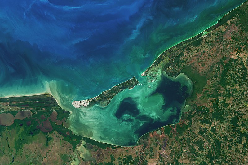
Along the coast of southeast Mexico, in the state of Campeche, wetlands and rivers give way to a shallow, swirling body of water. At 2500 square kilometers, Laguna de Términos is Mexico’s largest coastal lagoon. By definition, coastal lagoons maintain a connection to the sea through a restricted inlet. At Laguna de Términos, the flow of water between the lagoon and the Campeche Sound is impeded by Isla del Carmen, a 2.5-kilometer-wide barrier island. This arrangement means this lagoon has two inlets (or outlets): Sea water generally flows into the lagoon around the east of the island, and out past the western end. Campeche and its lagoon receive a healthy input of fresh water from a huge system of rivers flowing from the nearby states of Tabasco, Chiapas, and Guatemala. The flow varies depending on the season. When the Operational Land Imager (OLI) on the Landsat 8 satellite captured this image on January 20, 2017, the region was in the dry season, which runs from October through February. Four major river systems drain the watershed and feed the lagoon from the south and southwest, the largest of which is the Usumacinta River. Even in the dry season, these areas of the lagoon are fresher than other parts and more turbid—visible in this image as colorful swirls near the shore. Winds and tides also can stir up lagoon waters. Life is abundant here. Oyster beds thrive at the mouths of the major rivers. Beds of seagrass take hold in the saltier, calmer areas, particularly off of Isla del Carmen. And ringing much of the lagoon are uninterrupted patches of mangrove wetlands. The detailed image shows one such area on the eastern side of the lagoon. The mangroves and lagoon serve as a nursery for fish and shellfish, such as shrimp, which in turn support productive commercial fisheries in Campeche Sound. |
| Data | |
| Šaltinis | https://earthobservatory.nasa.gov/images/90893/laguna-de-terminos |
| Autorius | NASA Earth Observatory images by Joshua Stevens, using Landsat data from the U.S. Geological Survey. Story by Kathryn Hansen. |
Licencija
| Šis failas licencijuojamas viešajam naudojimui, nes jis buvo sukurtas NASA. NASA autorinių teisių taisyklės nurodo, kad „NASA medžiaga nėra saugoma autorinių teisių, išskyrus pažymėtą“ (NASA autorių teisių taisylės arba JPL paveikslėlių naudojimo tvarka). | ||
 |
Įspėjimai:
|
Rinkmenos istorija
Paspauskite ant datos/laiko, kad pamatytumėte rinkmeną tokią, kokia ji buvo tuo metu.
| Data/Laikas | Miniatiūra | Matmenys | Naudotojas | Paaiškinimas | |
|---|---|---|---|---|---|
| dabartinis | 07:05, 12 kovo 2021 | | 8 797 × 5 865 (6,89 MiB) | StellarHalo | {{Information |Description=Along the coast of southeast Mexico, in the state of Campeche, wetlands and rivers give way to a shallow, swirling body of water. At 2500 square kilometers, Laguna de Términos is Mexico’s largest coastal lagoon. By definition, coastal lagoons maintain a connection to the sea through a restricted inlet. At Laguna de Términos, the flow of water between the lagoon and the Campeche Sound is impeded by Isla del Carmen, a 2.5-kilometer-wide barrier island. This arrangeme... |
Paveikslėlio naudojimas
Paveikslėlis yra naudojamas šiuose puslapiuose:
Visuotinis rinkmenos naudojimas
Ši rinkmena naudojama šiose viki svetainėse:
- Naudojama en.wikipedia.org
- Naudojama es.wikipedia.org
- Naudojama ja.wikipedia.org
- Naudojama ru.wikipedia.org
- Naudojama www.wikidata.org
- Naudojama zh.wikipedia.org