Vaizdas:BlankMap-World-1985.png
Page contents not supported in other languages.
Vaizdas iš Vikipedijos, laisvosios enciklopedijos.

Didesnės raiškos iliustracija(1 500 × 740 taškų, rinkmenos dydis: 90 KiB, MIME tipas: image/png)

Ši byla yra iš bendros Wikimedia Commons nemokamų resursų duomenų bazės, palaikomos Wikimedia Foundation organizacijos. Norėdami sužinoti licencijavimo smulkmenas, žiūrėkite paveikslėlio aprašymą
Paveikslėlio aprašymas
Į paveikslėlio aprašymą

Aprašymas

Aprašymas

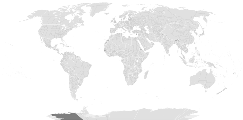
Blank political map of the world c.1985.

This is also officially accurate for the period between 1977 (South Africa imposes direct rule on Walvis Bay) - May 22 1990 (Unification of North and South Yemen). Unofficial border changes occurred between 1977 and 1990 which include in 1979 the US de facto hand over of the Panama Canal Zone to Panama (made official in December 1999) and in December 26, 1981 when the Iraq-Saudi Arabia Neutral Zone was partitioned between Iraq and Saudi Arabia but was only officially accepted in 1991.

Blank maps of the world for historical use
pre-1800

1 · 820 · 1500 · 1710


19th century

1840 · 1861 · 1866 · 1872 · 1898


20th century

1902 · 1912 · 1914 · WWI · Aug 1918 · 1920 · 1921 · 1924 · 1926 · 1935 · 1937 · Mar 1938 · Oct 1938 · Mar 1939 · Oct 1939 · WWII · Nov 1942 · May 1945 · 1957 · 1959 · 1962 · 1968 · 1970 · 1985 · 1990 · 1993


21st century

2000 · 2005 · 2007 · 2009 · Current

(this template: · view · discuss )
Data originally created before 2005 m. gegužės 13 d.
date QS:P,+2005-05-13T00:00:00Z/7,P1326,+2005-05-13T00:00:00Z/11
Šaltinis from wikipedia
Autorius several/unknown authors from Wikipedia/Commons; see Originalus įkėlimo įrašas and file upload log below for the latest
Kitos versijos

Derivative works of this file:

Licencija

w:lt:Creative Commons
autoriaus nurodymas dalinkis panašiai
Šiam failui taikoma Creative Commons Attribution-Share Alike 3.0 Unported licencija. Pateiktis atsakomybei.
Jūs galite:
  • dalintis – kopijuoti, platinti bei persiųsti šį darbą
  • pri(si)taikyti – adaptuoti darbą
Su šiomis sąlygomis:
  • autoriaus nurodymas – Turite pateikti atitinkamą kreditą, pateikti nuorodą į licenciją ir nurodyti, ar buvo atlikti pakeitimai. Tai galite padaryti bet kokiu būdu, bet ne taip, kad licencijos išdavėjas patvirtintų jus ar jūsų naudojimą.
  • dalinkis panašiai – Jei perdirbsite, redaguosite ar atkursite šį darbą, jį galėsite platinti tik su tokia pačia ar panašia į šią licencija.
Licencijos šablonas buvo priskirtas šiam failui kaip GFDL licencijos atnaujinimo dalis.
GNU head Suteikiamas leidimas kopijuoti, platinti ir/ar redaguoti šį dokumentą pagal GNU Free Documentation licencijos versijos 1.2 ar bet kurios vėlesnės versijos sąlygas, publikuotas Free Software Foundation; be nekintamų dalių, be priekinių ir galinių tekstinių žymų viršeliuose. Šios licencijos kopija įtraukta dalyje, pavadintoje GNU Free Documentation License. Pateiktis atsakomybei.

Originalus įkėlimo įrašas

From enwp File:BlankMap-World-1985.png:

  • 2006-07-01T03:50:46 Hoshie (talk | contribs) uploaded "File:BlankMap-World-1985.png" (Added Walvis Bay and the Trust Territory of the Pacific Islands. See talk.)
  • 2006-03-28T03:55:33 E Pluribus Anthony (talk | contribs) uploaded "File:BlankMap-World-1985.png" (World map: blank, with borders (1985))
  • 2006-03-26T17:41:59 E Pluribus Anthony (talk | contribs) uploaded "File:BlankMap-World-1985.png" (World map: blank, with borders (1985))
  • 2006-01-04T09:34:07 E Pluribus Anthony (talk | contribs) uploaded "File:BlankMap-World-1985.png" (World map: blank, with borders (1985))
  • 2005-09-19T13:49:05 E Pluribus Anthony (talk | contribs) uploaded "File:BlankMap-World-1985.png" (World map: blank, with borders (1985))
  • 2005-09-19T08:06:52 E Pluribus Anthony (talk | contribs) uploaded "File:BlankMap-World-1985.png" (World map: blank, with borders (1985))
  • 2005-09-19T02:56:16 E Pluribus Anthony (talk | contribs) uploaded "File:BlankMap-World-1985.png" (World map: blank, with borders (1985))
  • 2005-09-19T01:09:58 E Pluribus Anthony (talk | contribs) uploaded "File:BlankMap-World-1985.png" (World map: blank, with borders (1985))
  • 2005-05-12T23:25:33 Stern (talk | contribs) uploaded "File:BlankMap-World-1985.png" (minor changes (Denmark, Berlin, Caribbean))
  • other uploads which were not logged

Captions

Add a one-line explanation of what this file represents

Items portrayed in this file

vaizduoja

media type anglų

image/png

checksum anglų

d6bb7eef1d4554d5327a28d84023923685565f0d

data size anglų

92 304 Baitas

740 pikselis

1 500 pikselis

Rinkmenos istorija

Paspauskite ant datos/laiko, kad pamatytumėte rinkmeną tokią, kokia ji buvo tuo metu.

(Paskutiniai | Seniausi) Žiūrėti (10 naujesnių) () (10 | 20 | 50 | 100 | 250 | 500).
Data/LaikasMiniatiūraMatmenysNaudotojasPaaiškinimas
dabartinis17:56, 10 gruodžio 2019Versijos 17:56, 10 gruodžio 2019 miniatiūra1 500 × 740 (90 KiB)AKS471883Senegambia
14:04, 10 spalio 2017Versijos 14:04, 10 spalio 2017 miniatiūra1 500 × 740 (104 KiB)Expertseeker90Major edits and overhall! Continents, coastlines, lakes, rivers, islands, atolls and reefs added or fixed. National and internal boundaries re positioned and adjusted.
02:13, 8 sausio 2013Versijos 02:13, 8 sausio 2013 miniatiūra1 425 × 625 (49 KiB)CriostóirThese are the internationally recognised borders of Morocco (and as recognised by the UN)
23:40, 28 spalio 2012Versijos 23:40, 28 spalio 2012 miniatiūra1 425 × 625 (28 KiB)ApolikamixitosFixing Morocco borders.
16:08, 13 birželio 2009Versijos 16:08, 13 birželio 2009 miniatiūra1 425 × 625 (49 KiB)HoshieAdded a pixel around Timor island, fixed Cabinda (Angola), fixed the border of the Yemens and Saudi Arabia to where it was before the 2000 treaty based on this 1976 map [http://www.lib.utexas.edu/maps/middle_east_and_asia/middle_east_pol_1976.jpg http://w
04:21, 4 spalio 2007Versijos 04:21, 4 spalio 2007 miniatiūra1 425 × 625 (30 KiB)R-41~commonswikiRedone version
05:52, 24 rugsėjo 2007Versijos 05:52, 24 rugsėjo 2007 miniatiūra1 357 × 628 (45 KiB)Hoshieput the (N/S) Yemen boundary in white due to the fact the boundaries in southern Saudi Arabia have been disputed, undemarcated, or undisclosed over the years.
03:47, 6 rugpjūčio 2007Versijos 03:47, 6 rugpjūčio 2007 miniatiūra1 357 × 628 (45 KiB)Hoshieadded Cabinda, under same license as original.
13:53, 24 sausio 2007Versijos 13:53, 24 sausio 2007 miniatiūra1 357 × 628 (45 KiB)HoshieThe Yemen boundry with Saudi Arabia did not exist until 2000.
07:07, 12 rugpjūčio 2006Versijos 07:07, 12 rugpjūčio 2006 miniatiūra1 357 × 628 (45 KiB)HoshieI have removed the outline of the Trust Territory of the Pacific Islands and moved Walvis Bay down the coast of Namibia.
(Paskutiniai | Seniausi) Žiūrėti (10 naujesnių) () (10 | 20 | 50 | 100 | 250 | 500).

Paveikslėlis nenaudojamas nei viename straipsnyje.

Visuotinis rinkmenos naudojimas

Meta duomenys