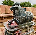
Vaizdas:13th century Nandi mandapa, Ramappa temples complex, Palampet Telangana India - 29.jpg

Didesnės raiškos iliustracija (3 099 × 3 024 taškų, rinkmenos dydis: 5,05 MiB, MIME tipas: image/jpeg)
| Ši byla yra iš bendros Wikimedia Commons nemokamų resursų duomenų bazės, palaikomos Wikimedia Foundation organizacijos. Norėdami sužinoti licencijavimo smulkmenas, žiūrėkite paveikslėlio aprašymą | Į paveikslėlio aprašymą |
Aprašymas
| Aprašymas13th century Nandi mandapa, Ramappa temples complex, Palampet Telangana India - 29.jpg |
English: The Ramappa temples complex is located about 65 kilometers northeast of Warangal (NH 163) and about 2 kilometers south of Palampet village near the 12th-century man made Ramappa lake for irrigation and drinking water. What is now a small village of Palampet in early 21st century, was Atukuru in 11th to 13th century, one of two major cities of the Reddys of Recerla – a Shudra caste family that had risen to be one of the most powerful governors (feudatories) within the Kakatiya empire. Devout Hindus, they built major and some of the most spectacular Shaiva, Vaishnava and Shakti temples in medieval Telingana. One group of many temples are found within 10 kilometers of Palampet, close to the Ramappa lake (another group is found in Pillalamarri). Their legacy is also recited in major Sanskrit inscriptions they left.
The Ramappa temple complex consists of two temples next to each other, another trikuta temple, a Sanskrit inscription pillar, a Nandi monument (above), and several mandapas.
For additional information about this temple along in the Ramappa temples complex context, and those who helped build it, please see: 1. M.A. Dhaky and Michael Meister (1996), Encyclopedia of Indian Temple Architecture, Volume 1, Part 3: Text, American Institute of Indian Studies, pp. 515–536 (particularly pp. 528–536). 2. Ghulam Yazdani (1929), Annual Report of the Archaeological Department of His Exalted Highness the Nizam's Dominions for 1336 F (1926-1927 AD), Archaeological Department of Hyderabad, pp. 1–3. |
| Data | |
| Šaltinis | Mano darbas |
| Autorius | Ms Sarah Welch |
| Fotografijos koordinatės | 18° 15′ 33,43″ N, 79° 56′ 36,73″ E | Šis ir kiti paveikslėliai: OpenStreetMap |
|---|
Licencija
| Šis failas prieinamas pagal Creative Commons CC0 1.0 Universal Public Domain Dedication. | |
| Asmuo, kuris susiejo darbą su šiuo dokumentu, nusprendė darbą pateikti Commons, atsisakydamas visų savo autoriaus teisių į darbą visame pasaulyje bei visų susijusių ar gretutinių teisių, kurias jis ar ji turėjo, tiek, kiek leidžia įstatymas. Darbai pagal CC0 atsisakymą nereikalauja autoriaus paminėjimo. Kai darbas cituojamas (naudojamas kitur), neprivalote gauti autoriaus patvirtinimo.
http://creativecommons.org/publicdomain/zero/1.0/deed.enCC0Creative Commons Zero, Public Domain Dedicationfalsefalse |
Captions
Items portrayed in this file
vaizduoja
some value
source of file anglų
31 rugpjūčio 2019
captured with anglų
iPhone XS anglų
18°15'33.430"N, 79°56'36.730"E
exposure time anglų
0.00047303689687795648 sekundė
f-number anglų
1,8
4,25 milimetras
ISO speed anglų
25
media type anglų
image/jpeg
checksum anglų
44128395844574501c4094a16c6825aa52e189c6
data size anglų
5 294 273 Baitas
3 024 pikselis
3 099 pikselis
Rinkmenos istorija
Paspauskite ant datos/laiko, kad pamatytumėte rinkmeną tokią, kokia ji buvo tuo metu.
| Data/Laikas | Miniatiūra | Matmenys | Naudotojas | Paaiškinimas | |
|---|---|---|---|---|---|
| dabartinis | 16:09, 1 balandžio 2021 |  | 3 099 × 3 024 (5,05 MiB) | Ms Sarah Welch | Uploaded own work with UploadWizard |
Paveikslėlio naudojimas
Paveikslėlis yra naudojamas šiuose puslapiuose:
Meta duomenys
Šioje iliustracijoje ar faile yra saugoma papildoma informacija, sukurta skaitmeninio fotoaparato, skenerio. Jei failas yra pakeistas, kai kurios detalės gali ne visai tiksliai aprašyti pakeistą iliustraciją.
| Fotoaparato gamintojas | Apple |
|---|---|
| Fotoaparato modelis | iPhone XS |
| Išlaikymas | 1/2 114 sek. (0,00047303689687796) |
| F numeris | f/1,8 |
| ISO greitis | 25 |
| Sukūrimo data ir laikas | 09:45, 31 rugpjūčio 2019 |
| Židinio nuotolis | 4,25 mm |
| Platuma | 18° 15′ 33,43″ N |
| Ilguma | 79° 56′ 36,73″ E |
| Aukštis | 199,1 metrai virš jūros lygio |
| Pasukimas | Standartinis |
| Horizontali raiška | 72 taškai colyje |
| Vertikali raiška | 72 taškai colyje |
| Naudota programinė įranga | 12.4 |
| Failas paskutinį kartą keistas | 09:45, 31 rugpjūčio 2019 |
| Y ir C pozicija | Centruotas |
| Išlaikymo programa | Paprasta programa |
| Exif versija | 2.21 |
| Skaitmenizavimo data ir laikas | 09:45, 31 rugpjūčio 2019 |
| kiekvieno komponento reikšmė |
|
| APEX užrakto greičio | 11,045872198246 |
| APEX diafragma | 1,6959938128384 |
| Šviesumas | 10,357756257994 |
| Išlaikymo paklaida | 0 |
| Matavimo režimas | Taškas |
| Blykstė | Blykstė nemirktelėjo, automatinis režimas |
| Datos ir laiko sekundės dalys | 408 |
| Duomenų generavimo datos ir laiko sekundės dalys | 408 |
| Pervedimo į skaitmeninį formatą datos ir laiko sekundės dalys | 408 |
| Palaikoma Flashpix versija | 1 |
| Spalvų pristatymas | Spalvos nekalibruotos |
| Jutimo režimas | Vienalustis spalvų zonos jutiklis |
| Scenos tipas | Tiesiogiai fotografuotas vaizdas |
| Išlaikymo režimas | Automatinis |
| Baltumo balansas | Automatinis baltumo balansas |
| Židinio nuotolis 35 mm juostoje | 26 mm |
| Scenos fiksavimo tipas | Paprastas |
| Greičio vienetai | Kilometrai per valandą |
| GPS gaviklio greitis | 0,0076527847031023 |
| Nuoroda vaizdo krypčiai | Tikroji kryptis |
| Nuotraukos kryptis | 32,30126953125 |

