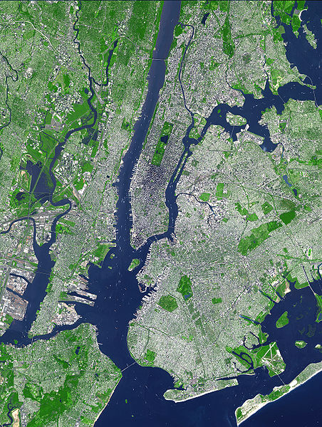
Vaizdas:Aster newyorkcity lrg.jpg

Šios peržiūros dydis: 452 × 600 taškų. Kitos 5 rezoliucijos: 181 × 240 taškų | 361 × 480 taškų | 578 × 768 taškų | 771 × 1 024 taškų | 1 964 × 2 607 taškų.
Didesnės raiškos iliustracija (1 964 × 2 607 taškų, rinkmenos dydis: 3,31 MiB, MIME tipas: image/jpeg)
Rinkmenos istorija
Paspauskite ant datos/laiko, kad pamatytumėte rinkmeną tokią, kokia ji buvo tuo metu.
| Data/Laikas | Miniatiūra | Matmenys | Naudotojas | Paaiškinimas | |
|---|---|---|---|---|---|
| dabartinis | 21:54, 8 rugpjūčio 2007 |  | 1 964 × 2 607 (3,31 MiB) | HenrikRomby | {{Information |Description=This false-color satellite image shows Greater New York City. The Island of Manhattan juts southward from top center, bordered by the Hudson River to the west and the East River to the east (north is straight up in this scene.) |
Paveikslėlio naudojimas
Paveikslėlis nenaudojamas nei viename straipsnyje.
Visuotinis rinkmenos naudojimas
Ši rinkmena naudojama šiose viki svetainėse:
- Naudojama af.wikipedia.org
- Naudojama ar.wikipedia.org
- Naudojama ast.wikipedia.org
- Naudojama bn.wikipedia.org
- Naudojama ca.wikipedia.org
- Naudojama da.wikipedia.org
- Naudojama de.wikipedia.org
- Naudojama el.wikipedia.org
- Naudojama en.wikipedia.org
- Topography
- Hudson County, New Jersey
- User:TimAlderson/Userboxes
- Hudson Waterfront
- List of bridges, tunnels, and cuts in Hudson County, New Jersey
- User:NYCRuss/Sandbox/New York City
- Trees of New York City
- Talk:Trees of New York City
- Wikipedia:WikiProject New York City/Environment Task Force
- Wikipedia:WikiProject New York City/400 Task Force
- Naudojama en.wikibooks.org
- Naudojama eo.wikipedia.org
- Naudojama es.wikipedia.org
- Naudojama et.wikipedia.org
- Naudojama fi.wikipedia.org
- Naudojama fr.wikipedia.org
- Naudojama fr.wikinews.org
- Naudojama gl.wikipedia.org
- Naudojama he.wikipedia.org
- Naudojama hr.wikipedia.org
- Naudojama hu.wikipedia.org
- Naudojama hy.wikipedia.org
- Naudojama id.wikipedia.org
- Naudojama it.wikipedia.org
- Naudojama ja.wikipedia.org
Žiūrėti visuotinį šios rinkmenos naudojimą.


