
Vaizdas:Antarctica map.jpg
Didesnės raiškos iliustracija (4 549 × 3 973 taškų, rinkmenos dydis: 6,18 MiB, MIME tipas: image/jpeg)
| Ši byla yra iš bendros Wikimedia Commons nemokamų resursų duomenų bazės, palaikomos Wikimedia Foundation organizacijos. Norėdami sužinoti licencijavimo smulkmenas, žiūrėkite paveikslėlio aprašymą |  |
Į paveikslėlio aprašymą |
| Warning | The original file is very high-resolution. It might not load properly or could cause your browser to freeze when opened at full size. |
|---|
| Leidėjas |
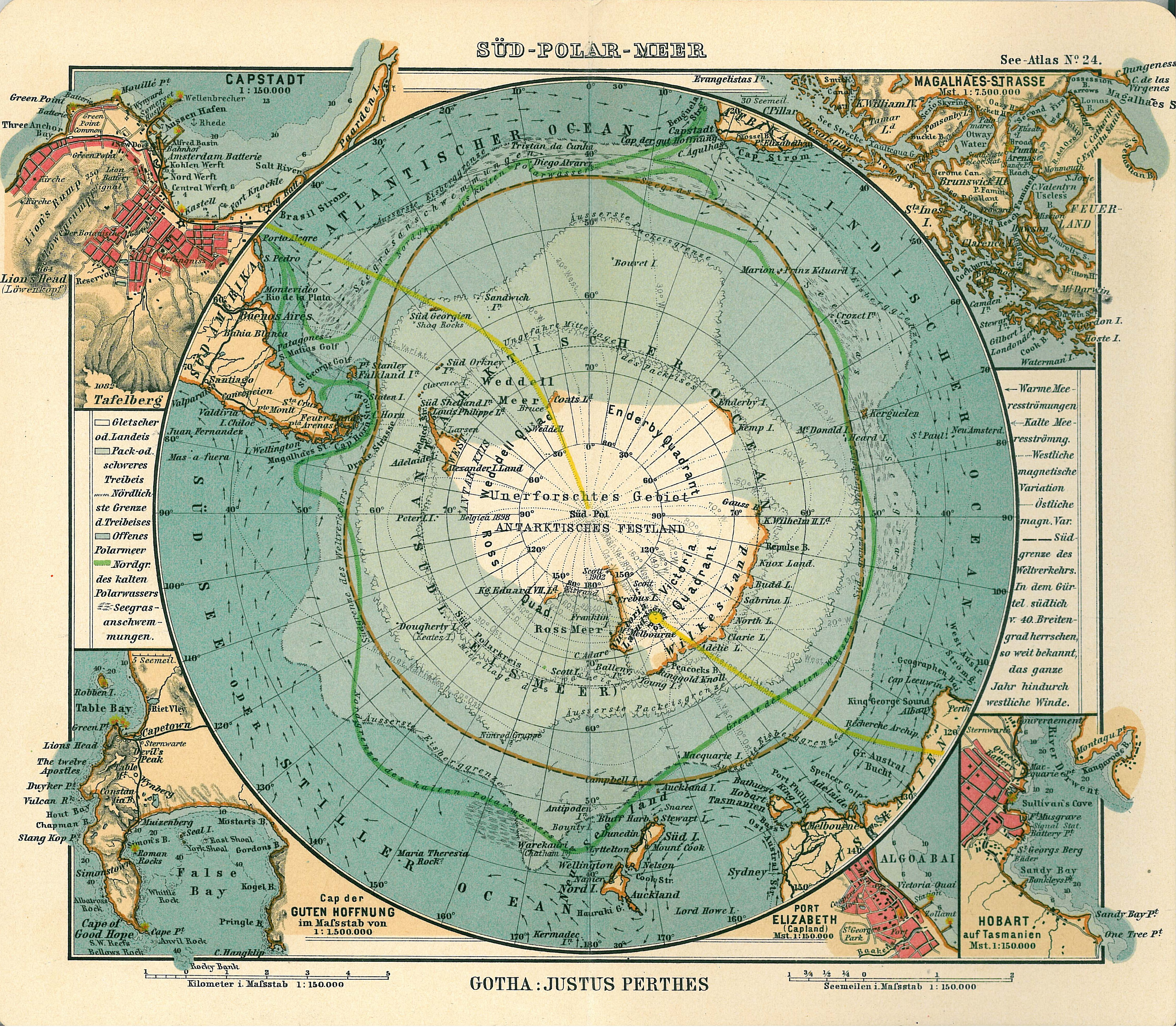
Justus Perthes |
||||
| Aprašymas |
Deutsch: Blatt 24, Süd-Polar-Meer
English: Page 24, Antarctica, Inset maps of Cape town, Cape of good hope, Magalhaes strait, Hobart, Port Elizabeth |
||||
| Publikavimo data | 1906 m. | ||||
| Publikavimo vieta | Gotha | ||||
| Šaltinis | See Atlas | ||||
| Leidimas (Šios rinkmenos panaudojimas kitur) |
|
||||
.jpg)
Rinkmenos istorija
Paspauskite ant datos/laiko, kad pamatytumėte rinkmeną tokią, kokia ji buvo tuo metu.
| Data/Laikas | Miniatiūra | Matmenys | Naudotojas | Paaiškinimas | |
|---|---|---|---|---|---|
| dabartinis | 20:08, 15 sausio 2007 | | 4 549 × 3 973 (6,18 MiB) | Martas011 | Category:Old maps of Antarctica Category:Maps of oceans Category:Maps of the Southern Ocean Good map of Antarctica, Justhus Perthes See Atlas 1906 Inset maps of Cape town, Cape of good hope, Magalhaes strait, Hobart, Port Elizabeth |
Paveikslėlio naudojimas
Paveikslėlis nenaudojamas nei viename straipsnyje.
Visuotinis rinkmenos naudojimas
Ši rinkmena naudojama šiose viki svetainėse:
- Naudojama avk.wikipedia.org
- Naudojama ca.wikipedia.org
- Naudojama de.wikipedia.org
- Naudojama en.wikipedia.org
- Naudojama eo.wikipedia.org
- Naudojama id.wikipedia.org
- Naudojama it.wikipedia.org
- Naudojama ja.wikipedia.org
- Naudojama nl.wikipedia.org
- Naudojama pl.wikipedia.org
- Naudojama pt.wikipedia.org
- Naudojama ru.wikipedia.org
- Naudojama zh.wikipedia.org