
Vaizdas:20191121 Guyana 0062 Georgetown sRGB (49295972987).jpg

Šios peržiūros dydis: 800 × 533 taškų. Kitos 6 rezoliucijos: 320 × 213 taškų | 640 × 427 taškų | 1 024 × 683 taškų | 1 280 × 853 taškų | 2 560 × 1 707 taškų | 5 472 × 3 648 taškų.
Didesnės raiškos iliustracija (5 472 × 3 648 taškų, rinkmenos dydis: 5,17 MiB, MIME tipas: image/jpeg)
| Ši byla yra iš bendros Wikimedia Commons nemokamų resursų duomenų bazės, palaikomos Wikimedia Foundation organizacijos. Norėdami sužinoti licencijavimo smulkmenas, žiūrėkite paveikslėlio aprašymą | .jpg?uselang=lt) |
Į paveikslėlio aprašymą |
.jpg)
.jpg?uselang=lt)
Aprašymas
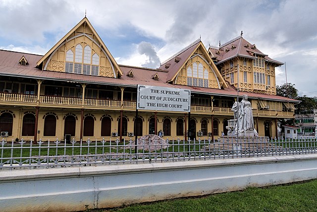
| Aprašymas | The High Court—renamed the Victoria Law Courts under the former Head of State’s rule—was completed in 1887, the Golden Jubilee year of the reign of Queen Victoria (r. 1837-1901). A marble statue of the Queen was commissioned to mark the Golden Jubilee but was not unveiled in front of the High Court [Supreme Court of Judicature] until 1894. In 1954 anti-colonial protesters dynamited the statue, blowing off the head and left hand. The statue was sent to England to be repaired. In 1970 when Guyana became a Cooperative Republic, the statue was relegated the Botanical Gardens. In 1990 the city’s mayor surprised the citizenry, and enraging some, by returning the statue to its original location. In June 2018 the statue was defaced with red paint. Georgetown, at the mouth of the Demerara River, is where the British established a town in 1781 when they captured the territory from the Dutch. The French colonized in 1782 making the town the capital named Longchamps. The Dutch reclaimed the area in 1784, renaming the town Stabroek after the president of the Dutch West India Company. The British returned and the town became Georgetown in 1812 in honor of King George III. Today Georgetown is the capital and commercial center of Guyana with the nickname ‘Garden City of the Caribbean’ for its tree-lined streets in the older parts of town. Guyana means “land of many waters” in an indigenous Amerindian language and was the original name for an entire region covering northern South America between the Orinoco (in Venezuela) and Amazon (in Brazil) Rivers. Christopher Columbus saw Guyana on his third voyage in 1498 and Sir Walter Raleigh published a fanciful description in 1595, but the first European colony was not established until 1616 with the arrival of the Dutch. They created two more colonies (in 1627 and 1752) before the British gained control in 1796 (when fighting the French who occupied the Netherlands) with the Dutch formally ceding the area in 1814. It officially became British Guiana in 1831. The economy was driven by sugar plantations worked by African slaves—more than 100,000 by 1830. Upon emancipation in 1838, agricultural production plummeted. Replacement workers were eventually found in India, with 240,000 indentured servants having been brought over by the time indentured labor was abolished in 1917. Bauxite mining beginning in 1914 created an industry that equals sugar (and rice) today (but gold is by far the leading export). Independence from the United Kingdom was achieved in 1966 with Guyana becoming an official republic within the British Commonwealth of Nations in 1970. Guyana is the only country in South America where English is the official language (but the majority of the population speaks Guyanese Creole, a version of Creole with a basis in English). |
| Data | |
| Šaltinis | 20191121_Guyana_0062 Georgetown sRGB |
| Autorius | Dan Lundberg |
| Fotografijos koordinatės | | Šis ir kiti paveikslėliai: OpenStreetMap |
|---|
.jpg¶ms=006.810444_N_-058.165429_E_globe:Earth_type:camera_source:Flickr_&language=lt)
Licencija
Šiam failui taikoma Creative Commons Attribution-Share Alike 2.0 Generic licencija.
- Jūs galite:
- dalintis – kopijuoti, platinti bei persiųsti šį darbą
- pri(si)taikyti – adaptuoti darbą
- Su šiomis sąlygomis:
- autoriaus nurodymas – Turite pateikti atitinkamą kreditą, pateikti nuorodą į licenciją ir nurodyti, ar buvo atlikti pakeitimai. Tai galite padaryti bet kokiu būdu, bet ne taip, kad licencijos išdavėjas patvirtintų jus ar jūsų naudojimą.
- dalinkis panašiai – Jei perdirbsite, redaguosite ar atkursite šį darbą, jį galėsite platinti tik su tokia pačia ar panašia į šią licencija.
| This image was originally posted to Flickr by Dan Lundberg at https://flickr.com/photos/9508280@N07/49295972987. It was reviewed on 2020 m. gegužės 21 d. by FlickreviewR 2 and was confirmed to be licensed under the terms of the cc-by-sa-2.0. |
Rinkmenos istorija
Paspauskite ant datos/laiko, kad pamatytumėte rinkmeną tokią, kokia ji buvo tuo metu.
| Data/Laikas | Miniatiūra | Matmenys | Naudotojas | Paaiškinimas | |
|---|---|---|---|---|---|
| dabartinis | 22:40, 21 gegužės 2020 | | 5 472 × 3 648 (5,17 MiB) | ZiaLater | Transferred from Flickr via #flickr2commons |
Paveikslėlio naudojimas
Paveikslėlis nenaudojamas nei viename straipsnyje.
Visuotinis rinkmenos naudojimas
Ši rinkmena naudojama šiose viki svetainėse:
- Naudojama de.wikipedia.org
- Naudojama el.wikipedia.org
- Naudojama en.wikipedia.org
- Naudojama es.wikipedia.org
- Naudojama ha.wikipedia.org
- Naudojama id.wikipedia.org
- Naudojama incubator.wikimedia.org
- Naudojama ka.wikipedia.org
- Naudojama nl.wikipedia.org
- Naudojama pt.wikipedia.org
.jpg)