
Vaizdas:1806 Cary Map of Asia, Polynesia, and Australia - Geographicus - Asia-cary-1806.jpg

Šios peržiūros dydis: 676 × 599 taškų. Kitos 6 rezoliucijos: 271 × 240 taškų | 542 × 480 taškų | 866 × 768 taškų | 1 155 × 1 024 taškų | 2 310 × 2 048 taškų | 4 000 × 3 546 taškų.
Didesnės raiškos iliustracija (4 000 × 3 546 taškų, rinkmenos dydis: 4,13 MiB, MIME tipas: image/jpeg)
| Ši byla yra iš bendros Wikimedia Commons nemokamų resursų duomenų bazės, palaikomos Wikimedia Foundation organizacijos. Norėdami sužinoti licencijavimo smulkmenas, žiūrėkite paveikslėlio aprašymą |  |
Į paveikslėlio aprašymą |
Aprašymas
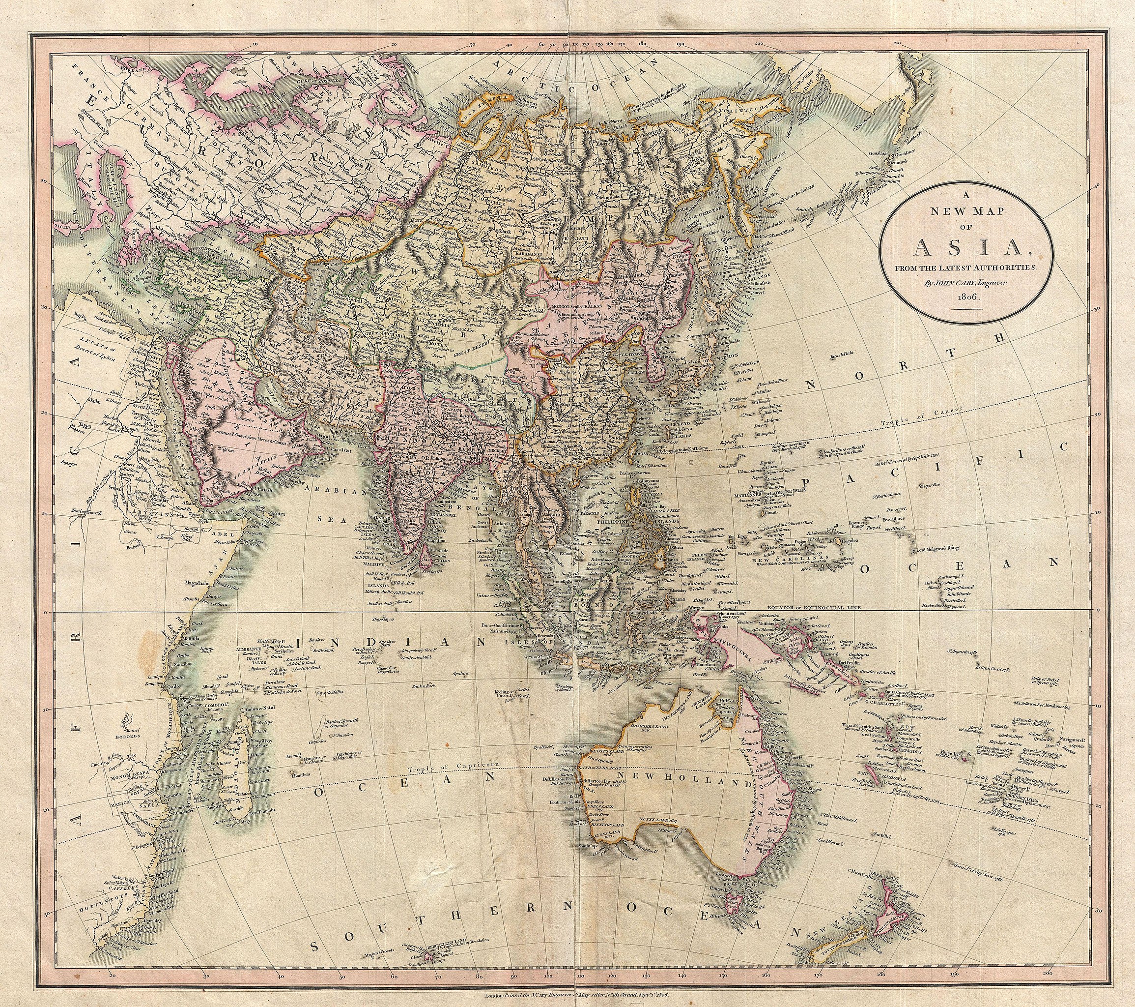
| John Cary: A New Map of Asia, From the Latest Authorities.
( |
||||||||||||||||||||||||||
|---|---|---|---|---|---|---|---|---|---|---|---|---|---|---|---|---|---|---|---|---|---|---|---|---|---|---|
| Autorius |
|
|||||||||||||||||||||||||
| Pavadinimas |
A New Map of Asia, From the Latest Authorities. |
|||||||||||||||||||||||||
| Aprašymas |
English: This is John Cary’s stunning 1806 map of Asia, Australia, and Polynesia. Covers from the Mediterranean to the Aleutian Islands and from the Arctic to South Africa, Australia, and New Zealand. This beautifully rendered map is truly a masterpiece of engraving, with mountain ranges, lakes, deserts, and rivers excited with such precision that the result appears almost three dimensional. Cary injects astounding detail throughout with countless towns, cities, geographical features, rivers, islands and bodies of water noted. In desert regions fresh water sources are noted. In the seas certain shoals and undersea are included. In China and Manchuria the Great Wall appears. Singapore islands is shown but not specifically named. The Liakhov Islands, in northern Siberia, which some believed to be entirely composed of fossil mammoth ivory, are noted as Shore Discovered by Hunters. Published by John Cary in his 1808 Cary's New Universal Atlas . |
|||||||||||||||||||||||||
| Data | 1806 m. (dated) | |||||||||||||||||||||||||
| Matmenys | aukštis: 18,5 in (46,9 cm); plotis: 21 in (53,3 cm) | |||||||||||||||||||||||||
| Leidimo numeris |
Geographicus link: Asia-cary-1806 |
|||||||||||||||||||||||||
| Šaltinis/Fotografas |
Cary, John, Cary's New Universal Atlas, containing distinct maps of all the principal states and kingdoms throughout the World. From the latest and best authorities extant. London: Printed for J. Cary, Engraver and Map-seller, No. 181, near Norfolk Street, Strand, 1808.
|
|||||||||||||||||||||||||
| Leidimas (Šios rinkmenos panaudojimas kitur) |
|
|||||||||||||||||||||||||
Rinkmenos istorija
Paspauskite ant datos/laiko, kad pamatytumėte rinkmeną tokią, kokia ji buvo tuo metu.
| Data/Laikas | Miniatiūra | Matmenys | Naudotojas | Paaiškinimas | |
|---|---|---|---|---|---|
| dabartinis | 01:09, 25 kovo 2011 | | 4 000 × 3 546 (4,13 MiB) | BotMultichillT | {{subst:User:Multichill/Geographicus |link=http://www.geographicus.com/P/AntiqueMap/Asia-cary-1806 |product_name=1806 Cary Map of Asia, Polynesia, and Australia |map_title=A New Map of Asia, From the Latest Authorities. |description=This is John Cary’s |
Paveikslėlio naudojimas
Paveikslėlis nenaudojamas nei viename straipsnyje.
Visuotinis rinkmenos naudojimas
Ši rinkmena naudojama šiose viki svetainėse:
- Naudojama ca.wikipedia.org
- Naudojama en.wikipedia.org
- Naudojama eo.wikipedia.org
- Naudojama es.wikipedia.org
- Naudojama fr.wikipedia.org
- Naudojama id.wikipedia.org
- Naudojama pt.wikipedia.org