
Vaizdas:United States 1860-1870.gif
Nėra didesnės raiškos varianto.
United_States_1860-1870.gif (787 × 483 taškų, rinkmenos dydis: 49 KiB, MIME tipas: image/gif, ciklinis, 28 kadrai, 35 s)
| Ši byla yra iš bendros Wikimedia Commons nemokamų resursų duomenų bazės, palaikomos Wikimedia Foundation organizacijos. Norėdami sužinoti licencijavimo smulkmenas, žiūrėkite paveikslėlio aprašymą |  |
Į paveikslėlio aprašymą |
Aprašymas
| Aprašymas |
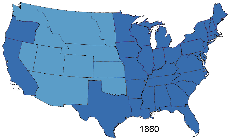
English: Animated map, about the American Civil War and the restoration of the southern states and the Union (made in Photoshop).
States of the Union (with full delegations in the U.S. Congress)
Union Territories (including the southern states before and during the war)
States of the Confederacy
Territories of the Confederacy |
| Šaltinis | Based on Creative Commons Licenced 1861 map and GNU-1864 Licenced map. Information from the Wikipedia articles Confederate States of America, List of US states by date of statehood, and has also just exterior sites When states Became states. Civil war borders Used from public domain Perry-Castañeda Library Map Collection 1861-1865 map. Border Between Arizona Territory (CSA) and New Mexico Territory Is That Depicted in public domain map Image: Map of CSA 4.png |
| Autorius | User:Roke~commonswiki |
Licencija
As the maps this was based on were licenced as GFDL and creative commons (not including the public domain maps), this is licenced under both licences.

|
Suteikiamas leidimas kopijuoti, platinti ir/ar redaguoti šį dokumentą pagal GNU Free Documentation licencijos versijos 1.2 ar bet kurios vėlesnės versijos sąlygas, publikuotas Free Software Foundation; be nekintamų dalių, be priekinių ir galinių tekstinių žymų viršeliuose. Šios licencijos kopija įtraukta dalyje, pavadintoje GNU Free Documentation License. |
| Šiam failui taikoma Creative Commons Attribution-Share Alike 3.0 Unported licencija. | ||
| ||
| Licencijos šablonas buvo priskirtas šiam failui kaip GFDL licencijos atnaujinimo dalis. |
Šiam failui taikoma Creative Commons Attribution-Share Alike 2.5 Generic licencija.
- Jūs galite:
- dalintis – kopijuoti, platinti bei persiųsti šį darbą
- pri(si)taikyti – adaptuoti darbą
- Su šiomis sąlygomis:
- autoriaus nurodymas – Turite pateikti atitinkamą kreditą, pateikti nuorodą į licenciją ir nurodyti, ar buvo atlikti pakeitimai. Tai galite padaryti bet kokiu būdu, bet ne taip, kad licencijos išdavėjas patvirtintų jus ar jūsų naudojimą.
- dalinkis panašiai – Jei perdirbsite, redaguosite ar atkursite šį darbą, jį galėsite platinti tik su tokia pačia ar panašia į šią licencija.
Rinkmenos istorija
Paspauskite ant datos/laiko, kad pamatytumėte rinkmeną tokią, kokia ji buvo tuo metu.
| Data/Laikas | Miniatiūra | Matmenys | Naudotojas | Paaiškinimas | |
|---|---|---|---|---|---|
| dabartinis | 17:02, 2 sausio 2015 | | 787 × 483 (49 KiB) | Sapph | Fixed incorrect succession order of North Carolina and Tennessee by swapping frames 10 and 11. |
| 08:00, 2 rugpjūčio 2006 |  | 787 × 483 (49 KiB) | Roke~commonswiki | Animated map showing Confederacy, American Civil War and re-admission of southern states to the Union, made in Photoshop. {{legend|#376dae|States of the Union}} {{legend|#5b9dc8|Territories of the Union (including occupied territory during and after the |
Paveikslėlio naudojimas
Paveikslėlis yra naudojamas šiuose puslapiuose:
Visuotinis rinkmenos naudojimas
Ši rinkmena naudojama šiose viki svetainėse:
- Naudojama af.wikipedia.org
- Naudojama ar.wikipedia.org
- Naudojama bn.wikipedia.org
- Naudojama ca.wikipedia.org
- Naudojama cs.wikipedia.org
- Naudojama en.wikipedia.org
- Historical regions of the United States
- History of the Southern United States
- Wikipedia:Featured picture candidates/March-2007
- Wikipedia:Featured picture candidates/CSA states evolution.gif
- Portal:American Civil War/Intro/images
- Portal:American Civil War/Intro/images/rotation/41
- Talk:United States/Archive 36
- Naudojama es.wikipedia.org
- Naudojama eu.wikipedia.org
- Naudojama fa.wikipedia.org
- Naudojama fr.wikipedia.org
- Naudojama it.wikipedia.org
- Naudojama ja.wikipedia.org
- Naudojama ms.wikipedia.org
- Naudojama pt.wikipedia.org
- Naudojama www.wikidata.org