
Vaizdas:UN Palestine Partition Versions 1947.jpg

Didesnės raiškos iliustracija (1 370 × 2 838 taškų, rinkmenos dydis: 1,46 MiB, MIME tipas: image/jpeg)
| Ši byla yra iš bendros Wikimedia Commons nemokamų resursų duomenų bazės, palaikomos Wikimedia Foundation organizacijos. Norėdami sužinoti licencijavimo smulkmenas, žiūrėkite paveikslėlio aprašymą |  |
Į paveikslėlio aprašymą |
Aprašymas
| Aprašymas |
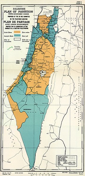
English: February 1956 Map of UN Partition Plan for Palestine, adopted 29 Nov 1947, with boundary of previous UNSCOP partition plan added in green. العربية: خريطة رسمية بعد قرار الأمم المتحدة بتاريخ 29 نوفمبر 1947م بتقسيم فلسطين إلى دولة عربية ويهودية وتحويل القدس لمدينة دولية. |
| Data | |
| Šaltinis | m0103_1b.gif on PLAN OF PARTITION is from UNGA Resolution 181 (27 Nov 1947). Overdrawn UNSCOP boundary is from United Nations Special Committee on Palestine, Report to the General Assembly, 3 Sep 1947, Volume II, A/364, Add. 1. |
| Autorius | Zero0000A/RES/181(II) |
| Kitos versijos |
.jpg)
.jpg)
.jpg)
.jpg)
Copyright status of map:
| This image is a map derived from a United Nations map.
Unless stated otherwise, UN maps are to be considered in the public domain. This applies worldwide. UN maps are, in principle, open source material and you can use them in your work or for making your own map. UN requests however that you delete the UN name, logo and reference number upon any modification to the map. Content of your map will be your responsibility. You can state in your publication, if you wish, something like: based on UN map … (map name, map number, revision number and date). See: Geospatial Information Section. And: Geospatial, location data for a better world. |
 |
Licencija
- Jūs galite:
- dalintis – kopijuoti, platinti bei persiųsti šį darbą
- pri(si)taikyti – adaptuoti darbą
- Su šiomis sąlygomis:
- autoriaus nurodymas – Turite pateikti atitinkamą kreditą, pateikti nuorodą į licenciją ir nurodyti, ar buvo atlikti pakeitimai. Tai galite padaryti bet kokiu būdu, bet ne taip, kad licencijos išdavėjas patvirtintų jus ar jūsų naudojimą.
- dalinkis panašiai – Jei perdirbsite, redaguosite ar atkursite šį darbą, jį galėsite platinti tik su tokia pačia ar panašia į šią licencija.

|
Šis paveikslėlis historical map (arba visos šio straipsnio iliustracijos) turėtų būti iš naujo sukurtas naudojant vektorinę grafiką, kaip, pavyzdžiui, SVG failas. To privalumus ir daugiau informacijos rasite straipsnyje Commons:Media for cleanup. Jei šio failo SVG versija jau sukurta, prašome ją įkelti. Po įkėlimo šios iliustracijos puslapyje pakeiskite šį šabloną į {{vector version available|naujas paveikslėlio pavadinimas.svg}}.
|


Rinkmenos istorija
Paspauskite ant datos/laiko, kad pamatytumėte rinkmeną tokią, kokia ji buvo tuo metu.
| Data/Laikas | Miniatiūra | Matmenys | Naudotojas | Paaiškinimas | |
|---|---|---|---|---|---|
| dabartinis | 15:07, 10 rugpjūčio 2013 | | 1 370 × 2 838 (1,46 MiB) | Zero0000 | User created page with UploadWizard |
Paveikslėlio naudojimas
Paveikslėlis yra naudojamas šiuose puslapiuose:
Visuotinis rinkmenos naudojimas
Ši rinkmena naudojama šiose viki svetainėse:
- Naudojama ar.wikipedia.org
- Naudojama arz.wikipedia.org
- Naudojama azb.wikipedia.org
- Naudojama az.wikipedia.org
- Naudojama bg.wikipedia.org
- Naudojama bn.wikipedia.org
- Naudojama cdo.wikipedia.org
- Naudojama cy.wikipedia.org
- Naudojama de.wikipedia.org
- Naudojama el.wikipedia.org
- Naudojama en.wikipedia.org
- 1948 Arab–Israeli War
- United Nations Partition Plan for Palestine
- Talk:United Nations Partition Plan for Palestine
- International zone
- International city
- Israel
- Arab localities in Israel
- Template talk:Largest cities of Israel
- Talk:1947–1948 civil war in Mandatory Palestine/Archive 2
- Wikipedia:Editor assistance/Requests/Archive 122
- Talk:Israel/Archive 47
- Talk:Israel/Archive 49
- November 1947
- Talk:Jerusalem/Archive 25
- User:Falcaorib
- Talk:Religion in Israel/Archive 1
- Nakba
- Wikipedia talk:Noticeboard for India-related topics/Archive 74
- User:Skingames2012/sandbox
- Naudojama es.wikipedia.org
- Naudojama et.wikipedia.org
- Naudojama eu.wikipedia.org
- Naudojama fa.wikipedia.org
- Naudojama fi.wikipedia.org
- Naudojama fr.wikipedia.org
Žiūrėti visuotinį šios rinkmenos naudojimą.