
Vaizdas:Tabaqah assad.jpg
Šios peržiūros dydis: 592 × 600 taškų. Kitos 2 rezoliucijos: 237 × 240 taškų | 631 × 639 taškų.
Didesnės raiškos iliustracija (631 × 639 taškų, rinkmenos dydis: 236 KiB, MIME tipas: image/jpeg)
| Ši byla yra iš bendros Wikimedia Commons nemokamų resursų duomenų bazės, palaikomos Wikimedia Foundation organizacijos. Norėdami sužinoti licencijavimo smulkmenas, žiūrėkite paveikslėlio aprašymą |  |
Į paveikslėlio aprašymą |
Aprašymas
| Aprašymas |
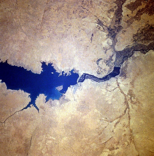
سد الفرات وبحيرة الأسد من الفضاء كانون الثاني 1996 English: Completed in 1973, the Tabaqah Dam (center of image) on the Euphrates River can be seen in this near-nadir view. The Tabaqah Dam is an earth filled dam nearly 197 feet (60 meters) high and 3 miles (5 km) long. The dam holds the waters of Lake Assad (center to left center of the image), a 50-mile (80 km) long and 5-mile (8 km) wide reservoir. Lake Assad and the Tabaqah Dam have not only provided increased hydroelectric power but the lake has doubled Syria’s irrigated land. Actual crop production has not reached the goals set by the Syrian government due to a number of problems including the gypsum subsoil of the region, and whether or not farmers could be attracted back to this scarsely populated area from urban areas or more crowded agricultural areas in other parts of the country. Also the water levels within Lake Assad remain low due mostly in part to construction of the Keban and Ataturk Dams in Turkey, which have reduced the water flow of the Euphrates River in Syria. |
| Data | |
| Šaltinis | http://eol.jsc.nasa.gov/sseop/EFS/photoinfo.pl?PHOTO=STS078-740-83 , http://upload.wikimedia.org/wikipedia/en/c/cf/Tabaqah_assad.jpg |
| Autorius | NASA |
This image or video was catalogued by one of the centers of the United States National Aeronautics and Space Administration (NASA) under Photo ID: STS078-740-83. This tag does not indicate the copyright status of the attached work. A normal copyright tag is still required. See Commons:Licensing. Other languages:
|
Licencija
| Šis failas licencijuojamas viešajam naudojimui, nes jis buvo sukurtas NASA. NASA autorinių teisių taisyklės nurodo, kad „NASA medžiaga nėra saugoma autorinių teisių, išskyrus pažymėtą“ (NASA autorių teisių taisylės arba JPL paveikslėlių naudojimo tvarka). | ||
 |
Įspėjimai:
|
Rinkmenos istorija
Paspauskite ant datos/laiko, kad pamatytumėte rinkmeną tokią, kokia ji buvo tuo metu.
| Data/Laikas | Miniatiūra | Matmenys | Naudotojas | Paaiškinimas | |
|---|---|---|---|---|---|
| dabartinis | 11:45, 3 vasario 2010 | | 631 × 639 (236 KiB) | Rehman | Flipped to align according to directions |
| 00:09, 29 spalio 2007 |  | 631 × 639 (200 KiB) | Amir syria | {{Information |Description=سد الفرات |Source=http://eol.jsc.nasa.gov/sseop/EFS/photoinfo.pl?PHOTO=STS078-740-83 , http://upload.wikimedia.org/wikipedia/en/c/cf/Tabaqah_assad.jpg |Date= |Author= |Permission= |other_versions= }} |
Paveikslėlio naudojimas
Paveikslėlis yra naudojamas šiuose puslapiuose:
Visuotinis rinkmenos naudojimas
Ši rinkmena naudojama šiose viki svetainėse:
- Naudojama ar.wikipedia.org
- Naudojama arz.wikipedia.org
- Naudojama be.wikipedia.org
- Naudojama bn.wikipedia.org
- Naudojama ca.wikipedia.org
- Naudojama ceb.wikipedia.org
- Naudojama de.wikipedia.org
- Naudojama en.wikipedia.org
- Naudojama es.wikipedia.org
- Naudojama fa.wikipedia.org
- Naudojama fr.wikipedia.org
- Naudojama he.wikipedia.org
- Naudojama hy.wikipedia.org
- Naudojama id.wikipedia.org
- Naudojama it.wikipedia.org
- Naudojama ko.wikipedia.org
- Naudojama nl.wikipedia.org
- Naudojama nn.wikipedia.org
- Naudojama no.wikipedia.org
- Naudojama pl.wikipedia.org
- Naudojama pt.wikipedia.org
- Naudojama ro.wikipedia.org
- Naudojama ru.wikipedia.org
- Naudojama sv.wikipedia.org
Žiūrėti visuotinį šios rinkmenos naudojimą.