
Vaizdas:Bazentin le Petit 14 July 1916 map.png

Didesnės raiškos iliustracija (1 000 × 632 taškų, rinkmenos dydis: 113 KiB, MIME tipas: image/png)
| Ši byla yra iš bendros Wikimedia Commons nemokamų resursų duomenų bazės, palaikomos Wikimedia Foundation organizacijos. Norėdami sužinoti licencijavimo smulkmenas, žiūrėkite paveikslėlio aprašymą |  |
Į paveikslėlio aprašymą |
Aprašymas
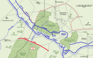
Map of Bazentin le Petit sector on the morning of 14 July 1916, Battle of Bazentin Ridge, showing the German second defensive position.
German trenches are shown in blue, including the communications trenches connecting to the (captured) first position. German barbed wire is shown as dotted blue lines. The start line of the assault brigades of the British 21st Division is shown in red. The position reached by the 21st Division and neighbouring 7th Division at 9 am is shown as the dashed red line.
Based on a trench map from the British Public Record Office.
| Šis darbas buvo paskelbtas viešajam naudojimui darbo autoriaus Gsl. Tai galioja visame pasaulyje. Kai kuriose šalyse tai negali būti legaliai leidžiama; jei taip: |
Rinkmenos istorija
Paspauskite ant datos/laiko, kad pamatytumėte rinkmeną tokią, kokia ji buvo tuo metu.
| Data/Laikas | Miniatiūra | Matmenys | Naudotojas | Paaiškinimas | |
|---|---|---|---|---|---|
| dabartinis | 13:38, 21 spalio 2005 | | 1 000 × 632 (113 KiB) | Igiveup | Map of Bazentin le Petit sector on the morning of 14 July 1916, Battle of Bazentin Ridge, showing the German second defensive position. German trenches are shown in blue, including the communications trenches connecting to the (captured) first position. |
Paveikslėlio naudojimas
Paveikslėlis yra naudojamas šiuose puslapiuose:
Visuotinis rinkmenos naudojimas
Ši rinkmena naudojama šiose viki svetainėse:
- Naudojama af.wikipedia.org
- Naudojama azb.wikipedia.org
- Naudojama ca.wikipedia.org
- Naudojama el.wikipedia.org
- Naudojama en.wikipedia.org
- Naudojama es.wikipedia.org
- Naudojama fr.wikipedia.org
- Naudojama hu.wikipedia.org
- Naudojama id.wikipedia.org
- Naudojama it.wikipedia.org
- Naudojama no.wikipedia.org