Vaizdas:Antarctica Without Ice Sheet.png
Page contents not supported in other languages.
Vaizdas iš Vikipedijos, laisvosios enciklopedijos.

Didesnės raiškos iliustracija(782 × 1 000 taškų, rinkmenos dydis: 675 KiB, MIME tipas: image/png)

Ši byla yra iš bendros Wikimedia Commons nemokamų resursų duomenų bazės, palaikomos Wikimedia Foundation organizacijos. Norėdami sužinoti licencijavimo smulkmenas, žiūrėkite paveikslėlio aprašymą
Paveikslėlio aprašymas
Į paveikslėlio aprašymą

Aprašymas

Aprašymas
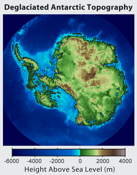
Русский: Рельеф Антарктиды с учетом поднятия земной коры после таяния ледников и повышения уровня океана
English: This is topographic map of Antarctica after removing the ice sheet and accounting for both isostatic rebound and sea level rise. Hence this map suggests what Antarctica may have looked like 35 million years ago, when the Earth was warm enough to prevent the formation of large-scale ice sheets in Antarctica.

Isostatic rebound is the result of the weight of the ice sheet depressing the land under it. After the ice is removed, the land will rise over a period of thousands of years by an amount approximately 1/3 as high as the ice sheet that was removed (because rock is 3 times as dense as ice). Approximately half the uplift occurs during the first two thousand years. If the ice sheet is removed over more than a few thousand years, then it is possible that a majority of the uplift will occur before the ice sheet fully disappears.

As indicated in the map, Antarctica consists of a large continental region (East Antarctica) and group of seas and smaller land regions (West Antarctica). Since the West Antarctic ice sheet is partially anchored below sea level, this region is less stable and more likely to be affected by global warming. Even so, it is likely that during the next century increased precipitation over Antarctica will offset melting.

Even in the event of severe sustained warming, it would take many thousands of years for Eastern Antarctica to be fully deglaciated.
Français : Carte topographique de l'Antarctique après avoir retirer la couche de glace et pris en compte le rebond isostatique ainsi que la montée du niveau de la mer Par conséquent cette carte montre ce à quoi l'Antarctique aurait pu ressembler il y a 35 millions d'années, quand la Terre était suffisament chause pour prévenir la formation d'une importante calotte glaciaire en Antarctique.

Le rebond isostatique est la conséquence de la couche de glace qui fait pression sur le sol et crée des dépressions. Après le retrait de la glace, le sol s'élève sur une période de milliers d'années par un rythme correspondant à un tiers de la hauteur de la couche de glace qui fut retirée (car la roche est trois fois plus dense que la glace). La moitié de l'élévation se fait pendant les deux premiers milliers d'années. Si la glace se retire sur une période dépassant plusieurs milliers d'année, il est possible que le rebond ait lieu avant que la couche de glace ne disparaisse complètement.

Comme montré sur la carte, l'Antarctique est composé d'une large région continentale (Antarctique oriental) et d'un groupe de mers et de petites régions terrestres (Antarctique occidental). Puisque la plaque glaciaire de l'Arctique occidental est en partie en dessous du niveau de la mer, cette région est moins stable et plus susceptible d'être affectée par le réchauffement climatique. En dépit de cela, des précipitation en Antarctique peuvent compenser la fonte. La fonte de l'Antarctique oriental prendra plusieurs milliers d'années, même en cas de réchauffement sévère et continu.
Data
Šaltinis http://www.globalwarmingart.com/wiki/File:Antarctica_Without_Ice_Sheet_png
Autorius Image created by Robert A. Rohde / Global Warming Art
Kitos versijos File:Deglaciated Antarctic Topography.png – with no description (internationalized)

Licencija

Robert A. Rohde, šio darbo autoriaus teisių savininkas, publikuoja jį su šiomis licencijomis:
GNU head Suteikiamas leidimas kopijuoti, platinti ir/ar redaguoti šį dokumentą pagal GNU Free Documentation licencijos versijos 1.2 ar bet kurios vėlesnės versijos sąlygas, publikuotas Free Software Foundation; be nekintamų dalių, be priekinių ir galinių tekstinių žymų viršeliuose. Šios licencijos kopija įtraukta dalyje, pavadintoje GNU Free Documentation License.
w:lt:Creative Commons
autoriaus nurodymas dalinkis panašiai
Autoriaus nurodymas: Robert A. Rohde
Jūs galite:
  • dalintis – kopijuoti, platinti bei persiųsti šį darbą
  • pri(si)taikyti – adaptuoti darbą
Su šiomis sąlygomis:
  • autoriaus nurodymas – Turite pateikti atitinkamą kreditą, pateikti nuorodą į licenciją ir nurodyti, ar buvo atlikti pakeitimai. Tai galite padaryti bet kokiu būdu, bet ne taip, kad licencijos išdavėjas patvirtintų jus ar jūsų naudojimą.
  • dalinkis panašiai – Jei perdirbsite, redaguosite ar atkursite šį darbą, jį galėsite platinti tik su tokia pačia ar panašia į šią licencija.
Galite pasirinkti, kurią licenciją norite naudoti.

Captions

Add a one-line explanation of what this file represents

Items portrayed in this file

vaizduoja

10 spalio 2012

media type anglų

image/png

checksum anglų

589d868b4476f71d9a736899eaa4a5aa88b985e9

data size anglų

690 846 Baitas

1 000 pikselis

782 pikselis

Rinkmenos istorija

Paspauskite ant datos/laiko, kad pamatytumėte rinkmeną tokią, kokia ji buvo tuo metu.

Data/LaikasMiniatiūraMatmenysNaudotojasPaaiškinimas
dabartinis19:56, 16 birželio 2015Versijos 19:56, 16 birželio 2015 miniatiūra782 × 1 000 (675 KiB)Szczureqlarger image
08:57, 10 spalio 2012Versijos 08:57, 10 spalio 2012 miniatiūra469 × 600 (316 KiB)Strannik27User created page with UploadWizard

Paveikslėlis nenaudojamas nei viename straipsnyje.

Visuotinis rinkmenos naudojimas

Ši rinkmena naudojama šiose viki svetainėse:

Meta duomenys