
Vaizdas:RogersCrkNorthHayward.gif
Nėra didesnės raiškos varianto.
RogersCrkNorthHayward.gif (640 × 440 taškų, rinkmenos dydis: 23 KiB, MIME tipas: image/gif)
| Ši byla yra iš bendros Wikimedia Commons nemokamų resursų duomenų bazės, palaikomos Wikimedia Foundation organizacijos. Norėdami sužinoti licencijavimo smulkmenas, žiūrėkite paveikslėlio aprašymą |  |
Į paveikslėlio aprašymą |
| Aprašymas |
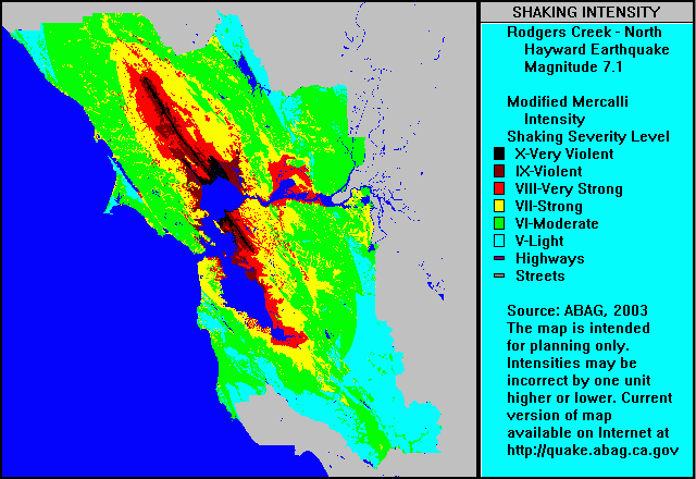
English: ABAG shake map for Rodgers Creek Fault Zone and north Hayward Fault Zone (single event) with colors representing ground motion in the Mercalli Intensity Scale. Note that colors used in the Mercalli article do not correspond to colors used in the ABAG map shown here — use Roman numerals for cross reference. |
| Data | m. rugsėjo 5 d. (pirminio įkėlimo data) |
| Šaltinis | Perkelta iš en.wikipedia į Vikiteką. |
| Autorius | Šią rinkmeną pirmiausia įkėlė Leonard G. iš anglų kalbos Vikipedija |
Licencija
This file is in the public domain because it is a work by or prepared for a tax-supported government agency, the Association of Bay Area Governments (ABAG).
From the ABAG web page [1]:
|
Originalus įkėlimo įrašas
Pirminis aprašymo puslapis buvo čia. Visi žemiau perteikti naudotojų vardai priklauso en.wikipedia.
- 2004-09-05 03:57 Leonard G. 640×440× (23379 bytes) ABAG shake map for Rodgers Creek and North Hayward - public domain image
Rinkmenos istorija
Paspauskite ant datos/laiko, kad pamatytumėte rinkmeną tokią, kokia ji buvo tuo metu.
| Data/Laikas | Miniatiūra | Matmenys | Naudotojas | Paaiškinimas | |
|---|---|---|---|---|---|
| dabartinis | 10:47, 1 gegužės 2009 | | 640 × 440 (23 KiB) | Carlog3 | {{Information |Description={{en|en:ABAG shake map for en:Rodgers Creek Fault Zone and north en:Hayward Fault Zone (single event) with colors representing ground motion in the en:Mercalli Intensity Scale. Note that colors used in th |
Paveikslėlio naudojimas
Paveikslėlis nenaudojamas nei viename straipsnyje.
Visuotinis rinkmenos naudojimas
Ši rinkmena naudojama šiose viki svetainėse:
- Naudojama de.wikipedia.org
- Naudojama en.wikipedia.org
- Naudojama en.wikibooks.org
- Naudojama en.wiktionary.org
- Naudojama fa.wikipedia.org
- Naudojama it.wikipedia.org
- Naudojama it.wikibooks.org
- Naudojama it.wikiversity.org
- Naudojama ja.wikipedia.org