
Vaizdas:Wallace03.jpg
Didesnės raiškos iliustracija (1 800 × 990 taškų, rinkmenos dydis: 2,27 MiB, MIME tipas: image/jpeg)
| Ši byla yra iš bendros Wikimedia Commons nemokamų resursų duomenų bazės, palaikomos Wikimedia Foundation organizacijos. Norėdami sužinoti licencijavimo smulkmenas, žiūrėkite paveikslėlio aprašymą |  |
Į paveikslėlio aprašymą |
Aprašymas
| Aprašymas |
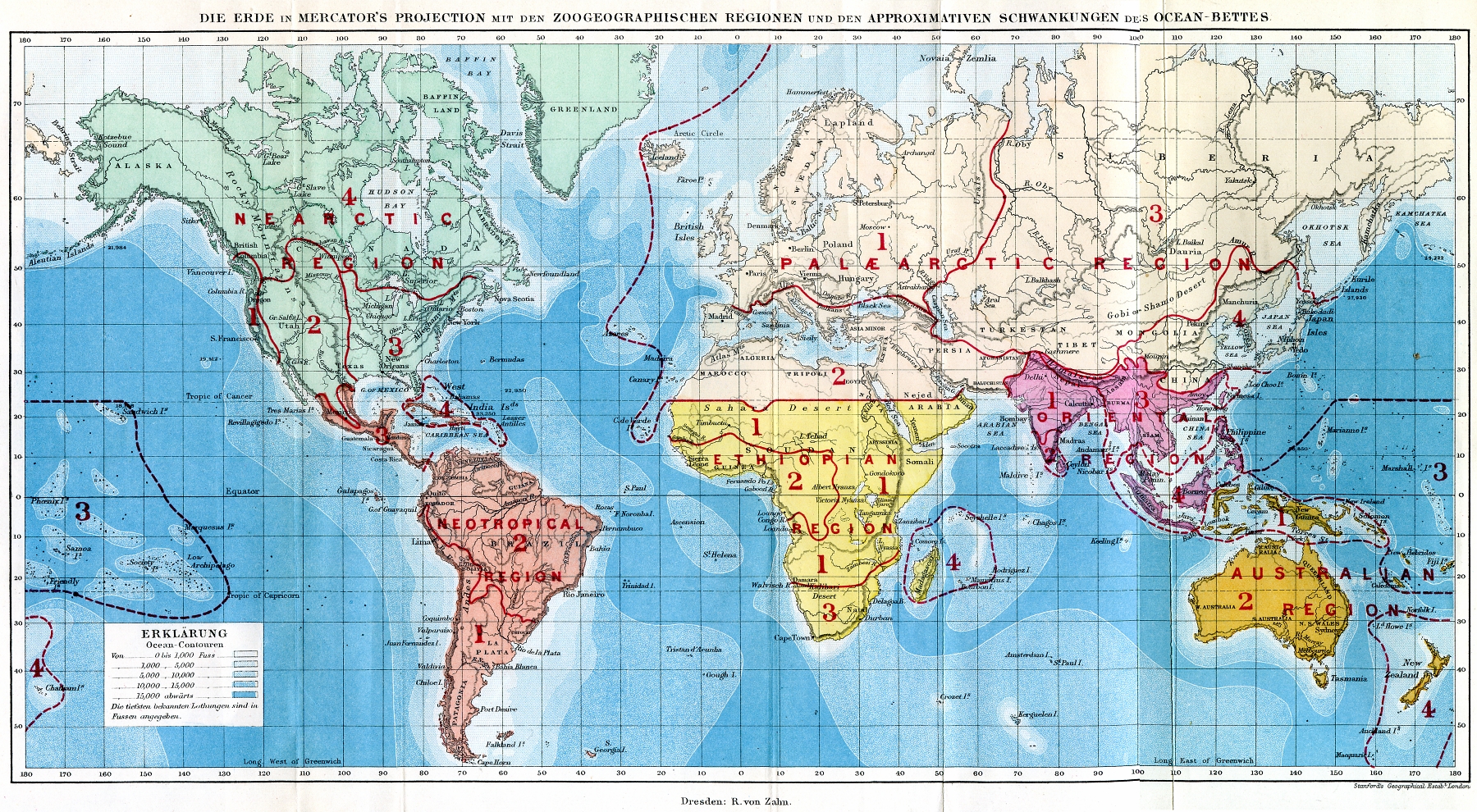
Deutsch: Weltkarte mit den Zoogeographischen Regionen
English: World map showing the zoogeographical regions
Español: Mapa del mundo que muestra las regiones zoogeográficas
|
||||
| Data | |||||
| Šaltinis |
Deutsch: Die geographische Verbreitung der Thiere; nebst einer Studie über die Verwandtschaften der lebenden und ausgestobenen Faunen in ihrer Beziehung zu den früheren Veränderungen der Erdoberfläche. Autorisirte deutsche Ausgabe von A. B. Meyer (Originaltitel: The geographical distribution of animals; with a study of the relations of living and extinct faunas as elucidating the past changes of the Earth's surface). Verlag R. von Zahn, Dresden.
English: Die geographische Verbreitung der Thiere; nebst einer Studie über die Verwandtschaften der lebenden und ausgestobenen Faunen in ihrer Beziehung zu den früheren Veränderungen der Erdoberfläche. Authorized German edition by A.B. Meyer (original title: The geographical distribution of animals; with a study of the relations of living and extinct faunas as elucidating the past changes of the Earth's surface). Verlag R. von Zahn, Dresden.
Español: Die geographische Verbreitung der Thiere ... [La distribución geográfica de los animales ...] Autorizada edición alemana, ed. por A.B. Meyer (título original completo: The geographical distribution of animals; with a study of the relations of living and extinct faunas as elucidating the past changes of the Earth's surface). Verlag R. von Zahn, Dresden. |
||||
| Autorius | Alfred Russel Wallace | ||||
| Leidimas (Šios rinkmenos panaudojimas kitur) |
|
||||
| Kitos versijos |
|
||||

Licencija
|
Šis failas yra viešo naudojimo tose šalyse, kuriose autorių teisės galiojimo netenka po 70 metų nuo autoriaus mirties.
| |
| This file has been identified as being free of known restrictions under copyright law, including all related and neighboring rights. | |
Rinkmenos istorija
Paspauskite ant datos/laiko, kad pamatytumėte rinkmeną tokią, kokia ji buvo tuo metu.
| Data/Laikas | Miniatiūra | Matmenys | Naudotojas | Paaiškinimas | |
|---|---|---|---|---|---|
| dabartinis | 22:22, 5 kovo 2007 | | 1 800 × 990 (2,27 MiB) | Dysmachus | {{Information| |Description= {{de|Weltkarte mit den Zoogeographischen Regionen}} {{en|World map showing the zoogeographical regions}} |Source=Wallace, A.R. (1876): ''Die geographische Verbreitung der Thiere''. - Deutsche Ausgabe von A.B. Meyer; Dresden: |
Paveikslėlio naudojimas
Paveikslėlis yra naudojamas šiuose puslapiuose:
Visuotinis rinkmenos naudojimas
Ši rinkmena naudojama šiose viki svetainėse:
- Naudojama af.wikipedia.org
- Naudojama ar.wikipedia.org
- Naudojama ast.wikipedia.org
- Naudojama azb.wikipedia.org
- Naudojama az.wikipedia.org
- Naudojama be-tarask.wikipedia.org
- Naudojama be.wikipedia.org
- Naudojama bg.wikipedia.org
- Naudojama bn.wikipedia.org
- Naudojama bs.wikipedia.org
- Naudojama ca.wikipedia.org
- Naudojama ce.wikipedia.org
- Naudojama ckb.wikipedia.org
- Naudojama cs.wikipedia.org
- Naudojama de.wikipedia.org
- Naudojama en.wikipedia.org
- Naudojama eo.wikipedia.org
- Naudojama es.wikipedia.org
- Naudojama fi.wikipedia.org
- Naudojama fr.wikipedia.org
- Naudojama gl.wikipedia.org
- Naudojama hr.wikipedia.org
- Naudojama hu.wikipedia.org
- Naudojama hy.wikipedia.org
Žiūrėti visuotinį šios rinkmenos naudojimą.