
Vaizdas:T J OBrien Lock and Dam.jpg

Šios peržiūros dydis: 800 × 533 taškų. Kitos 4 rezoliucijos: 320 × 213 taškų | 640 × 427 taškų | 1 024 × 683 taškų | 1 500 × 1 000 taškų.
Didesnės raiškos iliustracija (1 500 × 1 000 taškų, rinkmenos dydis: 279 KiB, MIME tipas: image/jpeg)
| Ši byla yra iš bendros Wikimedia Commons nemokamų resursų duomenų bazės, palaikomos Wikimedia Foundation organizacijos. Norėdami sužinoti licencijavimo smulkmenas, žiūrėkite paveikslėlio aprašymą |  |
Į paveikslėlio aprašymą |
| Aprašymas |
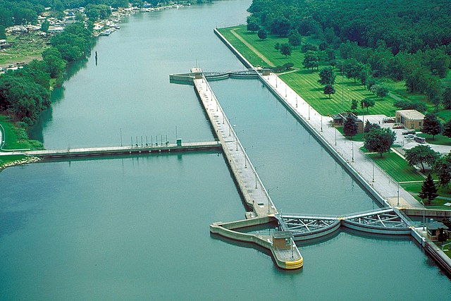
English: Aerial view of T.J. O’Brien Lock and Dam on the Calumet River, which is part of the Illinois Waterway. The dam is situated at river mile 326.5 on the Waterway (326.5 river miles up from the Mississippi River). T.J. O’Brien lock is the uppermost lock on the waterway, and there is not another barrier between the lock and Lake Michigan. There is very little elevation change in the lock, which serves mainly to regulate water flow from Lake Michigan into the waterway. The dam is located in Chicago, Illinois. |
|||
| Data | ||||
| Šaltinis |
U.S. Army Corps of Engineers Digital Visual Library Image page Image description page Digital Visual Library home page |
|||
| Autorius | Carol Arney, U.S. Army Corps of Engineers | |||
| Leidimas (Šios rinkmenos panaudojimas kitur) |
|
|||
| Vieta | Chicago, Illinois, USA |
| Fotografijos koordinatės | | Šis ir kiti paveikslėliai: OpenStreetMap |
|---|
Rinkmenos istorija
Paspauskite ant datos/laiko, kad pamatytumėte rinkmeną tokią, kokia ji buvo tuo metu.
| Data/Laikas | Miniatiūra | Matmenys | Naudotojas | Paaiškinimas | |
|---|---|---|---|---|---|
| dabartinis | 03:50, 3 balandžio 2007 | | 1 500 × 1 000 (279 KiB) | DanMS | {{Information | Description = {{en|Aerial view of T. J. O’Brien Lock and Dam on the Calumet River, which is part of the Illinois Waterway. The dam is situated at river mile 326 on the Waterway (326 river miles up from the Mississippi River). T.J. O� |
Paveikslėlio naudojimas
Paveikslėlis yra naudojamas šiuose puslapiuose:
Visuotinis rinkmenos naudojimas
Ši rinkmena naudojama šiose viki svetainėse:
- Naudojama arz.wikipedia.org
- Naudojama ceb.wikipedia.org
- Naudojama de.wikipedia.org
- Naudojama en.wikipedia.org
- Naudojama eo.wikipedia.org
- Naudojama fr.wikipedia.org
- Naudojama la.wikipedia.org
- Naudojama www.wikidata.org