
Vaizdas:ShepherdByzempire1265.jpg
Didesnės raiškos iliustracija (1 144 × 900 taškų, rinkmenos dydis: 281 KiB, MIME tipas: image/jpeg)
| Ši byla yra iš bendros Wikimedia Commons nemokamų resursų duomenų bazės, palaikomos Wikimedia Foundation organizacijos. Norėdami sužinoti licencijavimo smulkmenas, žiūrėkite paveikslėlio aprašymą |  |
Į paveikslėlio aprašymą |
Aprašymas
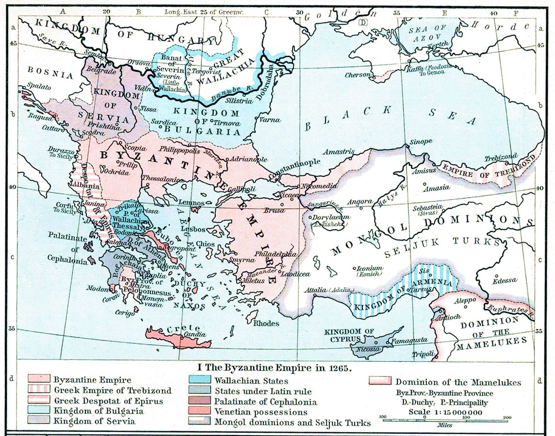
| Aprašymas | Map, The Byzantine Empire, 1265. | ||||||||||||||||||||||
| Data | |||||||||||||||||||||||
| Šaltinis | The Historical Atlas, William R. Shepherd, 1911. | ||||||||||||||||||||||
| Autorius |
|
||||||||||||||||||||||
| Kitos versijos |
Derivative works of this file: |
||||||||||||||||||||||

|
Šis paveikslėlis old map (arba visos šio straipsnio iliustracijos) turėtų būti iš naujo sukurtas naudojant vektorinę grafiką, kaip, pavyzdžiui, SVG failas. To privalumus ir daugiau informacijos rasite straipsnyje Commons:Media for cleanup. Jei šio failo SVG versija jau sukurta, prašome ją įkelti. Po įkėlimo šios iliustracijos puslapyje pakeiskite šį šabloną į {{vector version available|naujas paveikslėlio pavadinimas.svg}}.
|


Licencija
|
Šis failas yra viešo naudojimo tose šalyse, kuriose autorių teisės galiojimo netenka po 70 metų nuo autoriaus mirties.
| |
| This file has been identified as being free of known restrictions under copyright law, including all related and neighboring rights. | |
This media file is in the public domain in the United States. This applies to U.S. works where the copyright has expired, often because its first publication occurred prior to January 1, 1929, and if not then due to lack of notice or renewal. See this page for further explanation.
|
 | |
 |
This image might not be in the public domain outside of the United States; this especially applies in the countries and areas that do not apply the rule of the shorter term for US works, such as Canada, Mainland China (not Hong Kong or Macao), Germany, Mexico, and Switzerland. The creator and year of publication are essential information and must be provided. See Wikipedia:Public domain and Wikipedia:Copyrights for more details.
|
Rinkmenos istorija
Paspauskite ant datos/laiko, kad pamatytumėte rinkmeną tokią, kokia ji buvo tuo metu.
| Data/Laikas | Miniatiūra | Matmenys | Naudotojas | Paaiškinimas | |
|---|---|---|---|---|---|
| dabartinis | 18:28, 16 lapkričio 2022 | | 1 144 × 900 (281 KiB) | Gyalu22 | Reverted to version as of 16:26, 12 July 2009 (UTC) |
| 17:49, 20 gegužės 2016 |  | 1 144 × 900 (858 KiB) | Julieta39 | Cosmetic (see discussion file) | |
| 19:26, 12 liepos 2009 |  | 1 144 × 900 (281 KiB) | Alex:D | whitened | |
| 19:17, 12 liepos 2009 |  | 1 144 × 900 (281 KiB) | Alex:D | whitened | |
| 19:12, 12 liepos 2009 |  | 1 144 × 900 (281 KiB) | Alex:D | whitened | |
| 16:40, 21 gruodžio 2004 |  | 1 144 × 900 (272 KiB) | Mschlindwein | Map, The Byzantine Empire, 1265. The Historical Atlas, William R. Shepherd, 1911. |
Paveikslėlio naudojimas
Paveikslėlis yra naudojamas šiuose puslapiuose:
Visuotinis rinkmenos naudojimas
Ši rinkmena naudojama šiose viki svetainėse:
- Naudojama an.wikipedia.org
- Naudojama ar.wikipedia.org
- Naudojama azb.wikipedia.org
- Naudojama az.wikipedia.org
- Naudojama be-tarask.wikipedia.org
- Naudojama be.wikipedia.org
- Naudojama bg.wikipedia.org
- Naudojama ca.wikipedia.org
- Naudojama cs.wikipedia.org
- Naudojama de.wikipedia.org
- Naudojama el.wikipedia.org
- Naudojama en.wikipedia.org
Žiūrėti visuotinį šios rinkmenos naudojimą.