
Vaizdas:Luzon Strait n7184.jpg

Šios peržiūros dydis: 318 × 598 taškų. Kitos 2 rezoliucijos: 127 × 240 taškų | 542 × 1 020 taškų.
Didesnės raiškos iliustracija (542 × 1 020 taškų, rinkmenos dydis: 77 KiB, MIME tipas: image/jpeg)
| Ši byla yra iš bendros Wikimedia Commons nemokamų resursų duomenų bazės, palaikomos Wikimedia Foundation organizacijos. Norėdami sužinoti licencijavimo smulkmenas, žiūrėkite paveikslėlio aprašymą |  |
Į paveikslėlio aprašymą |
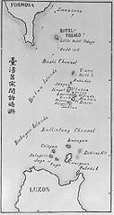
| Aprašymas | Old map of the Luzon Strait (not labeled), including the Bashi Channel, between Orchid Island (Botel Tobago on the map) of Taiwan and the Batan Islands of the Philippines. Names may be out of date. Japanese caption: "Islands between Taiwan and Luzon". | |||||
| Data | Nežinoma data | |||||
| Šaltinis |
From digital archive of the University of Tokyo. [1] Cropped by a-giâu. |
|||||
| Autorius | anthropologist Torii Ryūzō (1870-1953) | |||||
| Leidimas (Šios rinkmenos panaudojimas kitur) |
|


Rinkmenos istorija
Paspauskite ant datos/laiko, kad pamatytumėte rinkmeną tokią, kokia ji buvo tuo metu.
| Data/Laikas | Miniatiūra | Matmenys | Naudotojas | Paaiškinimas | |
|---|---|---|---|---|---|
| dabartinis | 02:30, 12 lapkričio 2004 | | 542 × 1 020 (77 KiB) | A-giâu | Old map of the Luzon Strait,(not labeled), including the Bashi Channel, between Orchid Island (Botel Tobago in the map) of Taiwan and the Batanes of the Philippines. Names may be out of date. From digital archive of the Universit |
Paveikslėlio naudojimas
Paveikslėlis yra naudojamas šiuose puslapiuose:
Visuotinis rinkmenos naudojimas
Ši rinkmena naudojama šiose viki svetainėse:
- Naudojama ar.wikipedia.org
- Naudojama ast.wikipedia.org
- Naudojama az.wikipedia.org
- Naudojama bcl.wikipedia.org
- Naudojama be.wikipedia.org
- Naudojama ca.wikipedia.org
- Naudojama ceb.wikipedia.org
- Naudojama cs.wikipedia.org
- Naudojama da.wikipedia.org
- Naudojama de.wikipedia.org
- Naudojama en.wikipedia.org
- Naudojama es.wikipedia.org
- Naudojama eu.wikipedia.org
- Naudojama fa.wikipedia.org
- Naudojama fr.wikipedia.org
- Naudojama he.wikipedia.org
- Naudojama hi.wikipedia.org
- Naudojama id.wikipedia.org
- Naudojama ilo.wikipedia.org
- Naudojama it.wikipedia.org
- Naudojama ja.wikipedia.org
- Naudojama ko.wikipedia.org
- Naudojama mk.wikipedia.org
- Naudojama nl.wikipedia.org
- Naudojama no.wikipedia.org
- Naudojama pam.wikipedia.org
Žiūrėti visuotinį šios rinkmenos naudojimą.