
Vaizdas:Liniadmowskiego.png
Nėra didesnės raiškos varianto.
Liniadmowskiego.png (545 × 600 taškų, rinkmenos dydis: 228 KiB, MIME tipas: image/png)
| Ši byla yra iš bendros Wikimedia Commons nemokamų resursų duomenų bazės, palaikomos Wikimedia Foundation organizacijos. Norėdami sužinoti licencijavimo smulkmenas, žiūrėkite paveikslėlio aprašymą |  |
Į paveikslėlio aprašymą |
| Aprašymas |
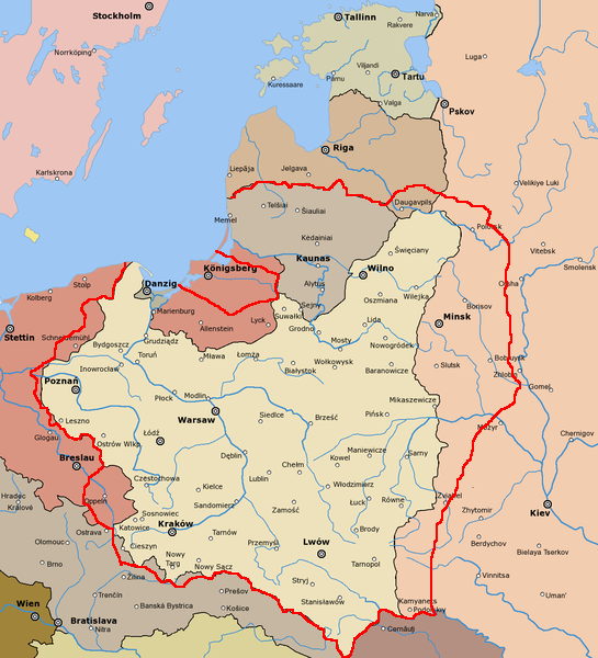
English: Dmowski's Line (borders of Poland proposed during the Paris Peace Conference) Polski: Linia Dmowskiego |
| Data | |
| Šaltinis |
derivative of File:Rzeczpospolita 1920.png; uploaded to pl wikipedia by Mix321 on 2 Dec 2006 data based on Małkowski, T. Rześniowiecki, J. Historia III, podręcznik dla klasy III gimnazjum, wyd. Gdańskie Wydawnictwo Oświatowe, Gdańsk, 2002 |
| Autorius | derivative: Mix321, original: listed below |
| Leidimas (Šios rinkmenos panaudojimas kitur) |
GFDL |
This image is a derivative work of the following images:
- File:Rzeczpospolita_1920.png licensed with Cc-by-sa-3.0-migrated, GFDL
- 2009-12-05T08:35:28Z DJ Sturm 2000x1534 (369919 Bytes) Correct borders, improved Estonia
- 2009-08-16T14:37:51Z Halibutt 2000x1534 (349775 Bytes) Reverted to version as of 06:33, 8 May 2005 (don't do this. Modify the svg version instead, without those horrible colours and copy-paste leftovers)
- 2009-03-27T14:30:53Z DJ Sturm 2000x1534 (368552 Bytes) Fixed borders of Estonia, Latvia, Lithuania, Soviet Union and Germany, added some towns.
- 2005-05-08T06:33:43Z Halibutt 2000x1534 (349775 Bytes) Reverted to earlier revision
- 2005-05-07T21:41:55Z DeirYassin 2000x1534 (314976 Bytes) Corrected borders of Latvia and Russia, Estonia and Russia according to real interwar, rather than current, borders; the Lithuanian claim is shown.
- 2005-05-07T20:50:35Z DeirYassin 2000x1534 (314976 Bytes)
- 2005-05-07T20:47:17Z DeirYassin 2000x1534 (314976 Bytes)
- 2005-04-07T21:04:53Z Halibutt 2000x1534 (349775 Bytes) New additions: borders of Czechoslovakia corrected, new towns added, more changes to follow. Any suggestions?
- 2005-04-05T07:53:46Z Halibutt 2000x1534 (267139 Bytes) Newer version
- 2005-04-04T07:02:24Z Halibutt 2000x1534 (236688 Bytes) new version: Hungaro-Czechoslovak border corrected and town names added
- 2005-04-02T12:06:46Z Halibutt 2000x1534 (148548 Bytes) new version, colours added
- 2005-04-02T05:30:08Z Halibutt 2000x1534 (151894 Bytes) Early version of my map of Poland and Eastern Europe between 1918 and 1945. So far it features the borders and major towns and cities, as well as the frontlines of the [[Polish-Bolshevik War]]. The colours and fonts and other

|
Suteikiamas leidimas kopijuoti, platinti ir/ar redaguoti šį dokumentą pagal GNU Free Documentation licencijos versijos 1.2 ar bet kurios vėlesnės versijos sąlygas, publikuotas Free Software Foundation; be nekintamų dalių, be priekinių ir galinių tekstinių žymų viršeliuose. Šios licencijos kopija įtraukta dalyje, pavadintoje GNU Free Documentation License. |
| Šiam failui taikoma Creative Commons Attribution-Share Alike 3.0 Unported licencija. | ||
| ||
| Licencijos šablonas buvo priskirtas šiam failui kaip GFDL licencijos atnaujinimo dalis. |
Rinkmenos istorija
Paspauskite ant datos/laiko, kad pamatytumėte rinkmeną tokią, kokia ji buvo tuo metu.
| Data/Laikas | Miniatiūra | Matmenys | Naudotojas | Paaiškinimas | |
|---|---|---|---|---|---|
| dabartinis | 11:46, 20 spalio 2010 | | 545 × 600 (228 KiB) | Mixx321 | dr |
| 18:05, 15 gruodžio 2009 |  | 514 × 496 (171 KiB) | Piotrus | {{Information |Description=:en: Dmowski's Line (borders of Poland proposed during the Paris Peace Conference)<br>:pl: Linia Dmowskiego |Source=uploaded to pl wikipedia by Mix321 on 2 Dec 2006 |Date=2 Dec 2006 |Author=Mix321 |Permi |
Paveikslėlio naudojimas
Paveikslėlis nenaudojamas nei viename straipsnyje.
Visuotinis rinkmenos naudojimas
Ši rinkmena naudojama šiose viki svetainėse:
- Naudojama lv.wikipedia.org