
Vaizdas:Hong Kong Skyline Restitch - Dec 2007.jpg

Šios peržiūros dydis: 800 × 347 taškų. Kitos 5 rezoliucijos: 320 × 139 taškų | 640 × 278 taškų | 1 024 × 444 taškų | 1 280 × 555 taškų | 4 250 × 1 844 taškų.
Didesnės raiškos iliustracija (4 250 × 1 844 taškų, rinkmenos dydis: 3,93 MiB, MIME tipas: image/jpeg)
| Ši byla yra iš bendros Wikimedia Commons nemokamų resursų duomenų bazės, palaikomos Wikimedia Foundation organizacijos. Norėdami sužinoti licencijavimo smulkmenas, žiūrėkite paveikslėlio aprašymą |  |
Į paveikslėlio aprašymą |
Aprašymas
| Aprašymas |
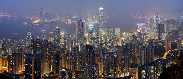
Deutsch: Skyline von Hong Kong betrachtet vom Victoria Peak. Zusammengesetzt aus 78 Aufnahmen (26×3).
English: A 26 segment × 3 exposure (78 frames in total) panoramic view of the Hong Kong skyline taken from a path around Victoria Peak.
Français : Vue panoramique de Hong Kong depuis un sentier de Victoria Peak. Image construite en assemblant 78 clichés (26 visées × 3 expositions) réalisés avecun appareil Canon 5D et un objectif 85mm f/1.8 réglé sur f/5.6. |
| Data | |
| Šaltinis | Mano darbas |
| Autorius | Diliff |
| Leidimas (Šios rinkmenos panaudojimas kitur) |
Summary:In using this image or any subsequent derivatives of it, you are required to release the image under the same license. As such, any reproduction of this image, in any medium, must appear with a copy of, or full URL of the license.Attribution of this image to the author (DAVID ILIFF) is also required, preferably in a prominent location near the image.No other conditions may be added to, or removed from this license without the permission of the author and copyright holder.Suggested attribution: "Photo by DAVID ILIFF. License: CC BY-SA 3.0"Please review the full license requirements carefully before using this image. If you would like to clarify the terms of the license or negotiate less restrictive commercial licensing outside of the bounds of GFDL/CC-BY-SA, please contact me by email, or if you don't have a Wikipedia account you can either leave a message on my talk page with your contact details and your request, or you can contact me on Facebook. Please also send a 'friend request' to ensure that I am aware of your message. |
| Kitos versijos |
|

| Fotografijos koordinatės | | Šis ir kiti paveikslėliai: OpenStreetMap |
|---|
|
Šis paveikslėlis buvo išrinktas dienos paveikslėliu 2008 m. liepos 6 d.. Jo aprašymas buvo: Kitomis kalbomis:
Bosanski: Panoramski pogled na hongkoški horizont sa staze kod vrha Viktorija. English: Panoramic view of the Hong Kong skyline taken from a path around Victoria Peak Español: Vista panorámica del distrito central de Hong Kong desde la Cumbre Victoria. Français : Vue panoramique de Hong Kong depuis un sentier de Victoria Peak. Image construite en assemblant 78 clichés (26 visées × 3 expositions) réalisés avec un appareil Canon 5D et un objectif 85mm f/1.8 réglé sur f/5.6. Italiano: Vista di Hong Kong dal Victoria Peak, Cina. Magyar: Hongkongi panorámakép a Viktória-csúcsról nézve Nederlands: Panorama van het stedelijk silhouet van Hongkong, gezien vanaf een pad rond Victoria Peak, de hoogste berg van Hongkong Island Português: Vista panorâmica do distrito central de Hong Kong, feita dos arredores do pico Victoria. Suomi: Näkymä Hong Kongin yli läheiseltä Victoria Peak -vuorelta Беларуская: Панарама Ганконга з гары Вікторыя-Пік. Українська: Панорама Гонконгу з гори Вікторія (Victoria Peak) मराठी: हाँग काँग चे परिदृश्य 한국어: 홍콩 빅토리아 피크에서 바라본 야경. العربية : صورة بانورامية للأفق في هونج كونج. |
| Kameros modelis | Canon EOS 5D |
|---|---|
| Apertūra | f/5.6 |
| Lęšiai | 85 mm f/1.8 |
Šis paveikslėlis buvo įvertintas naudojantis kokybiškų paveikslėlių taisyklėmis ir yra laikomas kokybišku paveikslėliu.
|
Licencija
Aš, šio darbo autoriaus teisių savininkas, publikuoju jį su šiomis licencijomis:

|
Suteikiamas leidimas kopijuoti, platinti ir/ar redaguoti šį dokumentą pagal GNU Free Documentation licencijos versijos 1.2 ar bet kurios vėlesnės versijos sąlygas, publikuotas Free Software Foundation; be nekintamų dalių, be priekinių ir galinių tekstinių žymų viršeliuose. Šios licencijos kopija įtraukta dalyje, pavadintoje GNU Free Documentation License. |
Šiam failui taikoma Creative Commons Attribution 3.0 Unported licencija.
- Jūs galite:
- dalintis – kopijuoti, platinti bei persiųsti šį darbą
- pri(si)taikyti – adaptuoti darbą
- Su šiomis sąlygomis:
- autoriaus nurodymas – Turite pateikti atitinkamą kreditą, pateikti nuorodą į licenciją ir nurodyti, ar buvo atlikti pakeitimai. Tai galite padaryti bet kokiu būdu, bet ne taip, kad licencijos išdavėjas patvirtintų jus ar jūsų naudojimą.
Galite pasirinkti, kurią licenciją norite naudoti.
Rinkmenos istorija
Paspauskite ant datos/laiko, kad pamatytumėte rinkmeną tokią, kokia ji buvo tuo metu.
| Data/Laikas | Miniatiūra | Matmenys | Naudotojas | Paaiškinimas | |
|---|---|---|---|---|---|
| dabartinis | 00:55, 30 balandžio 2008 | | 4 250 × 1 844 (3,93 MiB) | Diliff | == Summary == {{Information |Description={{en|A 26 segment x 3 exposure (78 frames in total) panoramic view of the Hong Kong skyline taken from a path around Victoria Peak. Taken by myself with a Canon 5D and 85mm f/1.8 lens at f/5.6.}} {{de|Skyline von H |
Paveikslėlio naudojimas
Paveikslėlis nenaudojamas nei viename straipsnyje.
Visuotinis rinkmenos naudojimas
Ši rinkmena naudojama šiose viki svetainėse:
- Naudojama ace.wikipedia.org
- Naudojama af.wikipedia.org
- Naudojama arc.wikipedia.org
- Naudojama ar.wikipedia.org
- Naudojama arz.wikipedia.org
- Naudojama as.wikipedia.org
- Naudojama azb.wikipedia.org
- Naudojama bn.wikipedia.org
- Naudojama bxr.wikipedia.org
- Naudojama ca.wikipedia.org
- Naudojama ceb.wikipedia.org
- Naudojama crh.wikipedia.org
- Naudojama cs.wikipedia.org
- Naudojama cv.wikipedia.org
- Naudojama da.wikipedia.org
- Naudojama de.wikipedia.org
- Naudojama diq.wikipedia.org
- Naudojama dv.wikipedia.org
- Naudojama el.wikipedia.org
- Naudojama en.wikipedia.org
- User:Diliff
- Portal:Politics/Featured content
- Wikipedia:WikiProject Urban studies and planning
- Portal:China/Selected article and pictures
- Wikipedia:WikiProject Countries/Assessment
- Portal:Capitalism/Selected article
- Portal:Capitalism/Selected article/1
- Wikipedia:Featured pictures/Places/Panorama
- Wikipedia:WikiProject China/Featured and good content
- Portal:China/Selected picture
- Portal:Architecture/Townscape images
Žiūrėti visuotinį šios rinkmenos naudojimą.