
Vaizdas:Guadeloupe - Location Map (2013) - GLP - UNOCHA.svg

Didesnės raiškos iliustracija (SVG rinkmena, formaliai 250 × 250 taškų, rinkmenos dydis: 263 KiB)
| Ši byla yra iš bendros Wikimedia Commons nemokamų resursų duomenų bazės, palaikomos Wikimedia Foundation organizacijos. Norėdami sužinoti licencijavimo smulkmenas, žiūrėkite paveikslėlio aprašymą | _-_GLP_-_UNOCHA.svg?uselang=lt) |
Į paveikslėlio aprašymą |
_-_GLP_-_UNOCHA.svg)
_-_GLP_-_UNOCHA.svg?uselang=lt)
Aprašymas
| Aprašymas |
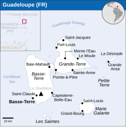
English: Locator map of Guadeloupe. |
| Data | |
| Šaltinis |
English: Guadeloupe (France) Locator Map (ReliefWeb), ESRI, UNCS, Natural Earth, The Times Atlas of the World |
| Autorius | |
| SVG genesis | Šis vektorinis paveikslėlis sukurtas su Inkscape. |
Licencija
- Jūs galite:
- dalintis – kopijuoti, platinti bei persiųsti šį darbą
- pri(si)taikyti – adaptuoti darbą
- Su šiomis sąlygomis:
- autoriaus nurodymas – Turite pateikti atitinkamą kreditą, pateikti nuorodą į licenciją ir nurodyti, ar buvo atlikti pakeitimai. Tai galite padaryti bet kokiu būdu, bet ne taip, kad licencijos išdavėjas patvirtintų jus ar jūsų naudojimą.
 This map is part of a collection of 216 free country maps, created by the UN Office for the Coordination of Humanitarian Affairs (OCHA), to be used in print, web or broadcast products.
The ReliefWeb Location Maps released here are maps that highlight a country, its capital, major populated places and the surrounding regions. Attribution Requirements
Using the map without modifications: ensure that the sources and the disclaimer are below the map. Credit as follows: "Credit: OCHA". For use with alteration: remove the OCHA logo and disclaimer following any modification to the map, but keep the data sources as mentioned below the map. Credit the modified map as follows: "Based on OCHA map". You are responsible for the content of your map. We are keen to receive your feedback and hear how you used OCHA's maps. We would be grateful if you would notify us by e-mail and share your work with us. UN Disclaimer
The designations employed and the presentation of material of this map do not imply the expression of any opinion whatsoever on the part of the Secretariat of the United Nations concerning the legal status of any country, territory, city or area or of its authorities or concerning the delimitation of its frontiers or boundaries. |
Rinkmenos istorija
Paspauskite ant datos/laiko, kad pamatytumėte rinkmeną tokią, kokia ji buvo tuo metu.
| Data/Laikas | Miniatiūra | Matmenys | Naudotojas | Paaiškinimas | |
|---|---|---|---|---|---|
| dabartinis | 12:57, 10 rugsėjo 2016 | | 250 × 250 (263 KiB) | Wereldburger758 | Resized page to drawing. Removal watermark. Validation of image. |
| 04:27, 21 balandžio 2014 |  | 254 × 254 (288 KiB) | UN OCHA maps bot | == {{int:filedesc}} == {{Information |description={{en|1=Locator map of Guadeloupe.}} |date=2013 |source={{en|1=[http://reliefweb.int/map/guadeloupe-france/guadaloupe-fr-location-map-2013 Guadeloupe (France) Locator Map (ReliefWeb)]... |
Paveikslėlio naudojimas
Paveikslėlis yra naudojamas šiuose puslapiuose:
Visuotinis rinkmenos naudojimas
Ši rinkmena naudojama šiose viki svetainėse:
- Naudojama en.wikipedia.org
- Naudojama fr.wikipedia.org
- Naudojama io.wikipedia.org
- Naudojama mk.wikipedia.org
- Naudojama ml.wikipedia.org
- Naudojama mr.wikipedia.org
- Naudojama my.wikipedia.org
_-_GLP_-_UNOCHA.svg)