
Vaizdas:Cyprus2022OSM.png
Šios peržiūros dydis: 800 × 522 taškų. Kitos 6 rezoliucijos: 320 × 209 taškų | 640 × 418 taškų | 1 024 × 669 taškų | 1 280 × 836 taškų | 2 560 × 1 671 taškų | 4 212 × 2 750 taškų.
Didesnės raiškos iliustracija (4 212 × 2 750 taškų, rinkmenos dydis: 2,67 MiB, MIME tipas: image/png)
| Ši byla yra iš bendros Wikimedia Commons nemokamų resursų duomenų bazės, palaikomos Wikimedia Foundation organizacijos. Norėdami sužinoti licencijavimo smulkmenas, žiūrėkite paveikslėlio aprašymą |  |
Į paveikslėlio aprašymą |
Aprašymas
| Aprašymas |
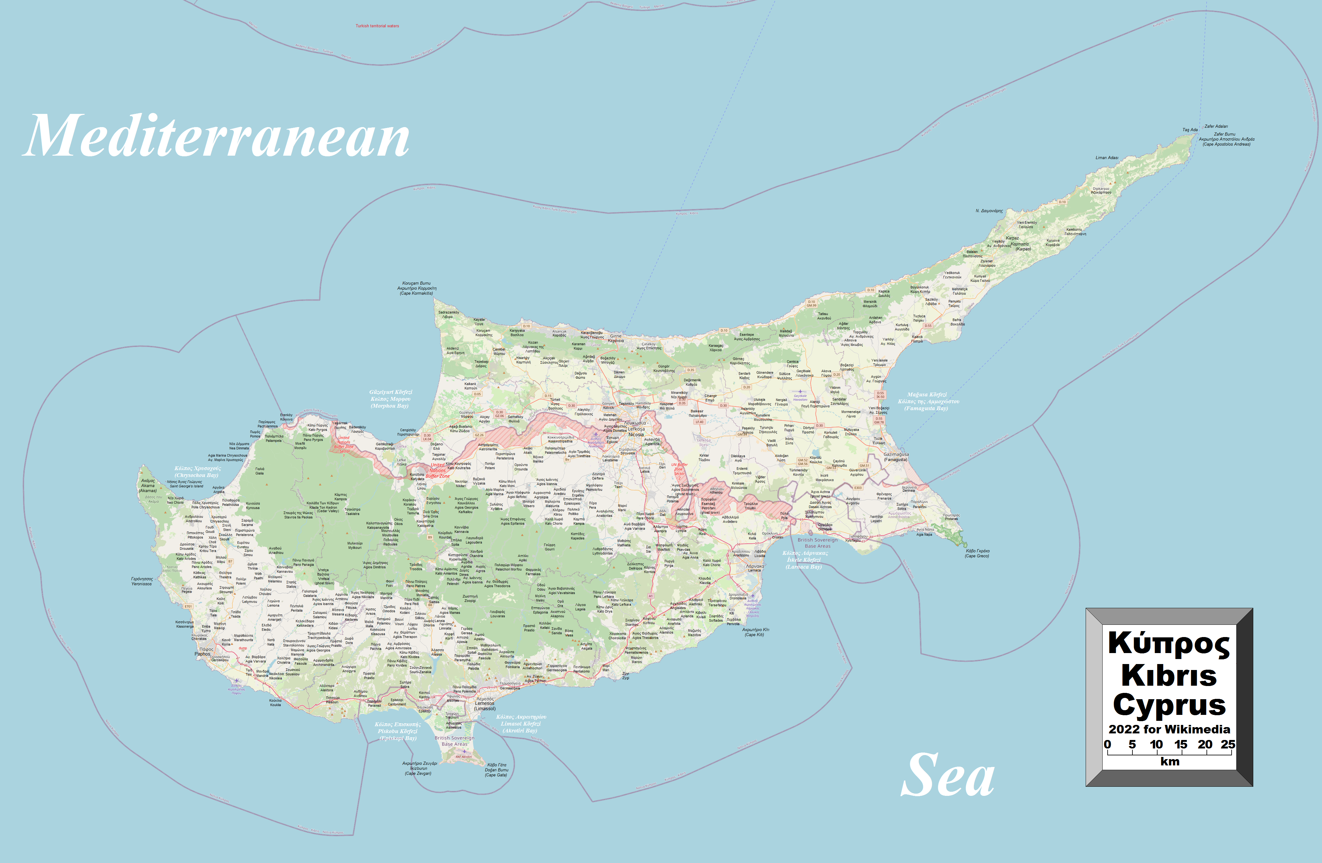
English: This map of Cyprus shows the country's cities, towns, villages and some other geographical details, and is likely the most comprehensive map of the country in this respect that you'll find anywhere online. It has been stitched together from panels of Open Street Map (which is freely licensed to all) with details plotted by the uploader, among which are a great number of inhabited places (and even the odd uninhabited place), the British Sovereign Base Areas, the United Nations Buffer Zone along with the Green Line (shown, however, in red and purple, respectively), coastal features and a few other things (see if you can spot the word "dump" on the map). A lack of room made it impossible to include all the information that users might like to see. To avoid having too much clutter on the map, places in the self-declared republic in the north are given their Turkish names with their Greek names underneath (without Latin-script transliteration), while places still under the southern republic's administration are given their Greek names with Latin-script transliterations underneath (finding their Turkish names was a bit of a problem). In a very few cases, English names (if different) are also given. Also, not absolutely every village has been included. |
| Data | |
| Šaltinis | Mano darbas |
| Autorius | Kelisi |
| Leidimas (Šios rinkmenos panaudojimas kitur) |
The aforesaid website is freely usable to all. |
Licencija
Aš, šio darbo autoriaus teisių savininkas, publikuoju jį su šia licencija:
This file is licensed under the Creative Commons Attribution-Share Alike 4.0 International license.
- Jūs galite:
- dalintis – kopijuoti, platinti bei persiųsti šį darbą
- pri(si)taikyti – adaptuoti darbą
- Su šiomis sąlygomis:
- autoriaus nurodymas – Turite pateikti atitinkamą kreditą, pateikti nuorodą į licenciją ir nurodyti, ar buvo atlikti pakeitimai. Tai galite padaryti bet kokiu būdu, bet ne taip, kad licencijos išdavėjas patvirtintų jus ar jūsų naudojimą.
- dalinkis panašiai – Jei perdirbsite, redaguosite ar atkursite šį darbą, jį galėsite platinti tik su tokia pačia ar panašia į šią licencija.
Rinkmenos istorija
Paspauskite ant datos/laiko, kad pamatytumėte rinkmeną tokią, kokia ji buvo tuo metu.
| Data/Laikas | Miniatiūra | Matmenys | Naudotojas | Paaiškinimas | |
|---|---|---|---|---|---|
| dabartinis | 22:46, 21 gegužės 2022 | | 4 212 × 2 750 (2,67 MiB) | Kelisi | Uploaded own work with UploadWizard |
Paveikslėlio naudojimas
Paveikslėlis yra naudojamas šiuose puslapiuose:
Visuotinis rinkmenos naudojimas
Ši rinkmena naudojama šiose viki svetainėse:
- Naudojama en.wikipedia.org
- Naudojama sl.wikipedia.org