
Vaizdas:Constitution gardens satellite image.jpg
Nėra didesnės raiškos varianto.
Constitution_gardens_satellite_image.jpg (650 × 275 taškų, rinkmenos dydis: 123 KiB, MIME tipas: image/jpeg)
| Ši byla yra iš bendros Wikimedia Commons nemokamų resursų duomenų bazės, palaikomos Wikimedia Foundation organizacijos. Norėdami sužinoti licencijavimo smulkmenas, žiūrėkite paveikslėlio aprašymą |  |
Į paveikslėlio aprašymą |
Aprašymas
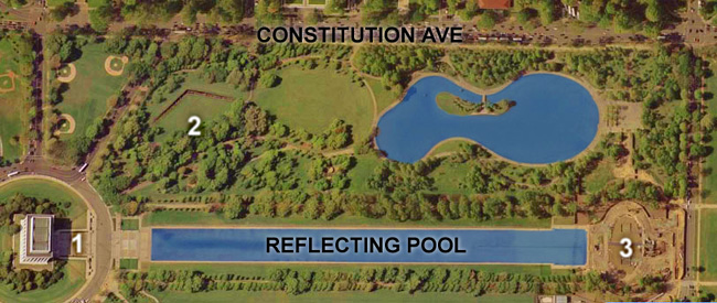
| Aprašymas | Satellite image of Constitution Gardens, Washington, D.C.. 1) Lincoln Memorial; 2) Vietnam War Memorial; 3) World War II Memorial (then-under construction). |
| Data | Satellite image taken in April 2002 |
| Šaltinis | United States Geological Survey satellite image of the National Mall in Washington, DC. Taken April 26, 2002 (see File:National Mall big satelite image.jpg). |
| Autorius | USGS, cropped and labelled by Postdlf |
3.reflecting pool. 2.constitution garden
Licencija
This work is in the public domain in the United States because it is a work prepared by an officer or employee of the United States Government as part of that person’s official duties under the terms of Title 17, Chapter 1, Section 105 of the US Code.
Note: This only applies to original works of the Federal Government and not to the work of any individual U.S. state, territory, commonwealth, county, municipality, or any other subdivision. This template also does not apply to postage stamp designs published by the United States Postal Service since 1978. (See § 313.6(C)(1) of Compendium of U.S. Copyright Office Practices). It also does not apply to certain US coins; see The US Mint Terms of Use.
|
 | |
| This file has been identified as being free of known restrictions under copyright law, including all related and neighboring rights. | ||
Rinkmenos istorija
Paspauskite ant datos/laiko, kad pamatytumėte rinkmeną tokią, kokia ji buvo tuo metu.
| Data/Laikas | Miniatiūra | Matmenys | Naudotojas | Paaiškinimas | |
|---|---|---|---|---|---|
| dabartinis | 01:27, 3 rugsėjo 2007 | | 650 × 275 (123 KiB) | Postdlf | == Summary == {{Information |Description=Map of Constitution Gardens, Washington, D.C. |Source=USGS satellite image |Date=Satellite image taken April 22, 2002 |Author= USGS, cropped and |
Paveikslėlio naudojimas
Paveikslėlis yra naudojamas šiuose puslapiuose:
Visuotinis rinkmenos naudojimas
Ši rinkmena naudojama šiose viki svetainėse:
- Naudojama ba.wikipedia.org
- Naudojama en.wikipedia.org
- Naudojama fr.wikipedia.org
- Naudojama he.wikipedia.org
- Naudojama kk.wikipedia.org
- Naudojama pt.wikipedia.org
- Naudojama zh.wikipedia.org