
Vaizdas:A Map of Europe for the Illustration of King Alfred's Anglo-Saxon translation of Orosius. Engraved by J. Bayly.jpg

Didesnės raiškos iliustracija (3 254 × 3 220 taškų, rinkmenos dydis: 1,97 MiB, MIME tipas: image/jpeg)
| Ši byla yra iš bendros Wikimedia Commons nemokamų resursų duomenų bazės, palaikomos Wikimedia Foundation organizacijos. Norėdami sužinoti licencijavimo smulkmenas, žiūrėkite paveikslėlio aprašymą |  |
Į paveikslėlio aprašymą |
Aprašymas
| Aprašymas |
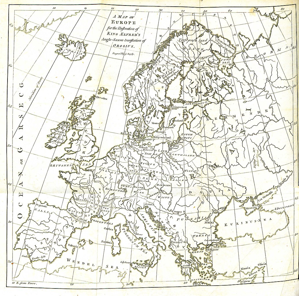
English: Folding engraved map published in: Daines Barrington (ed./transl.), King Ælfred’s Orosius: The Anglo-Saxon Version, from the Historian Orosius. By Ælfred the Great. Together with an English Translation from the Anglo-Saxon. London: printed by W. Bowyer and J. Nichols: and sold by S. Baker and G. Leigh; T. Payne; and B. White, 1773, II, after p. 260. Drawn up by Johann Reinhold Forster and his son Georg Forster (uncredited, see: Johann Reinhold Forster, Geschichte der Entdeckungen und Schiffahrten im Norden. Frankfurt an der Oder: Carl Gottlieb Strauß, 1784, pp. XIII–XIV, and: Walter Goffart, Historical Atlases: The First Three Hundred Years, 1570–1870. Chicago/London: The University of Chicago Press, 2003, pp. 197, 200). Engraved by John Bayly. Description of the map (Barrington, op. cit., I, p. xxiv): |
| Šaltinis | Daines Barrington (ed./transl.), King Ælfred’s Orosius: The Anglo-Saxon Version, from the Historian Orosius. By Ælfred the Great |
| Autorius | Drawn up by Johann Reinhold Forster and his son Georg Forster |
Licencija
|
Šis failas yra viešo naudojimo tose šalyse, kuriose autorių teisės galiojimo netenka po 100 metų nuo autoriaus mirties. Šis darbas laikomas viešo naudojimo Jungtinėse Amerikos Valstijose, nes jis buvo įregistruotas JAV Autorių Teisių Biure ar publikuotas iki 1929 m. sausio 1 d. | |
| This file has been identified as being free of known restrictions under copyright law, including all related and neighboring rights. | |
| Annotations | This image is annotated: View the annotations at Commons |
Rinkmenos istorija
Paspauskite ant datos/laiko, kad pamatytumėte rinkmeną tokią, kokia ji buvo tuo metu.
| Data/Laikas | Miniatiūra | Matmenys | Naudotojas | Paaiškinimas | |
|---|---|---|---|---|---|
| dabartinis | 14:11, 29 rugpjūčio 2016 | | 3 254 × 3 220 (1,97 MiB) | BarringtonForster | Engraved folding map published in: Daines Barrington (ed./transl.), ''King Ælfred’s Orosius: The Anglo-Saxon Version, from the Historian Orosius. By Ælfred the Great. Together with an English Translation from the Anglo-Saxon''. London: printed by W... |
Paveikslėlio naudojimas
Paveikslėlis yra naudojamas šiuose puslapiuose:
Visuotinis rinkmenos naudojimas
Ši rinkmena naudojama šiose viki svetainėse:
- Naudojama en.wikipedia.org
- Naudojama pl.wikipedia.org
- Naudojama pt.wikipedia.org
- Naudojama sl.wikipedia.org