
Vaizdas:The development of the German linguistic area.gif
Šios peržiūros dydis: 800 × 504 taškų. Kitos 3 rezoliucijos: 320 × 202 taškų | 640 × 403 taškų | 1 031 × 650 taškų.
Didesnės raiškos iliustracija (1 031 × 650 taškų, rinkmenos dydis: 160 KiB, MIME tipas: image/gif, ciklinis, 5 kadrai, 5,0 s)
| Ši byla yra iš bendros Wikimedia Commons nemokamų resursų duomenų bazės, palaikomos Wikimedia Foundation organizacijos. Norėdami sužinoti licencijavimo smulkmenas, žiūrėkite paveikslėlio aprašymą |  |
Į paveikslėlio aprašymą |

Aprašymas
| Aprašymas |
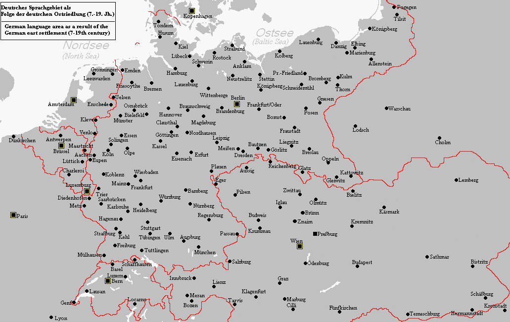
English: The map shows the development of the German linguistic area from around 1000 to modern times. |
| Šaltinis | Mano darbas |
| Autorius | Postmann Michael |
Licencija
Aš, šio darbo autoriaus teisių savininkas, publikuoju jį su šiomis licencijomis:

|
Suteikiamas leidimas kopijuoti, platinti ir/ar redaguoti šį dokumentą pagal GNU Free Documentation licencijos versijos 1.2 ar bet kurios vėlesnės versijos sąlygas, publikuotas Free Software Foundation; be nekintamų dalių, be priekinių ir galinių tekstinių žymų viršeliuose. Šios licencijos kopija įtraukta dalyje, pavadintoje GNU Free Documentation License. |
| Šiam failui taikoma Creative Commons Attribution-Share Alike 3.0 Unported licencija. | ||
| ||
| Licencijos šablonas buvo priskirtas šiam failui kaip GFDL licencijos atnaujinimo dalis. |
Šiam failui taikomos Creative Commons Attribution-Share Alike 2.5 Generic, 2.0 Generic bei 1.0 Generic licencijos.
- Jūs galite:
- dalintis – kopijuoti, platinti bei persiųsti šį darbą
- pri(si)taikyti – adaptuoti darbą
- Su šiomis sąlygomis:
- autoriaus nurodymas – Turite pateikti atitinkamą kreditą, pateikti nuorodą į licenciją ir nurodyti, ar buvo atlikti pakeitimai. Tai galite padaryti bet kokiu būdu, bet ne taip, kad licencijos išdavėjas patvirtintų jus ar jūsų naudojimą.
- dalinkis panašiai – Jei perdirbsite, redaguosite ar atkursite šį darbą, jį galėsite platinti tik su tokia pačia ar panašia į šią licencija.
Galite pasirinkti, kurią licenciją norite naudoti.
Rinkmenos istorija
Paspauskite ant datos/laiko, kad pamatytumėte rinkmeną tokią, kokia ji buvo tuo metu.
| Data/Laikas | Miniatiūra | Matmenys | Naudotojas | Paaiškinimas | |
|---|---|---|---|---|---|
| dabartinis | 14:16, 15 rugsėjo 2010 | | 1 031 × 650 (160 KiB) | Wester | Reverted to version as of 08:50, 13 December 2006 |
| 23:56, 25 sausio 2007 |  | 1 248 × 1 472 (2,07 MiB) | Postmann Michael~commonswiki | Revise. A more detailed map description soon follows. | |
| 02:31, 15 gruodžio 2006 |  | 1 472 × 1 472 (571 KiB) | Postmann Michael~commonswiki | This map shows the development of the German linguistic area as a result of the so-called "German east settlement". This contained the period of time for 12th to 14th century and contained about 500,000 people. The first settlers were predominantly "North | |
| 11:50, 13 gruodžio 2006 |  | 1 031 × 650 (160 KiB) | Postmann Michael~commonswiki | The map shows the emergence of the German linguistic area in the course of the so-called "German east settlement" in the period of time of 7 until the 19th century. This map was done by me. |
Paveikslėlio naudojimas
Paveikslėlis nenaudojamas nei viename straipsnyje.
Visuotinis rinkmenos naudojimas
Ši rinkmena naudojama šiose viki svetainėse:
- Naudojama ar.wikipedia.org
- Naudojama de.wikipedia.org
- Naudojama en.wikipedia.org
- Naudojama ro.wikipedia.org
- Naudojama sl.wikipedia.org
- Naudojama tr.wikipedia.org
- Naudojama uk.wikipedia.org
- Naudojama www.wikidata.org