
Vaizdas:Yellow River Delta 1995-09-18.jpg
Šios peržiūros dydis: 800 × 534 taškų. Kitos 5 rezoliucijos: 320 × 214 taškų | 640 × 427 taškų | 1 024 × 684 taškų | 1 280 × 855 taškų | 3 001 × 2 004 taškų.
Didesnės raiškos iliustracija (3 001 × 2 004 taškų, rinkmenos dydis: 3,18 MiB, MIME tipas: image/jpeg)
| Ši byla yra iš bendros Wikimedia Commons nemokamų resursų duomenų bazės, palaikomos Wikimedia Foundation organizacijos. Norėdami sužinoti licencijavimo smulkmenas, žiūrėkite paveikslėlio aprašymą |  |
Į paveikslėlio aprašymą |
| Aprašymas |
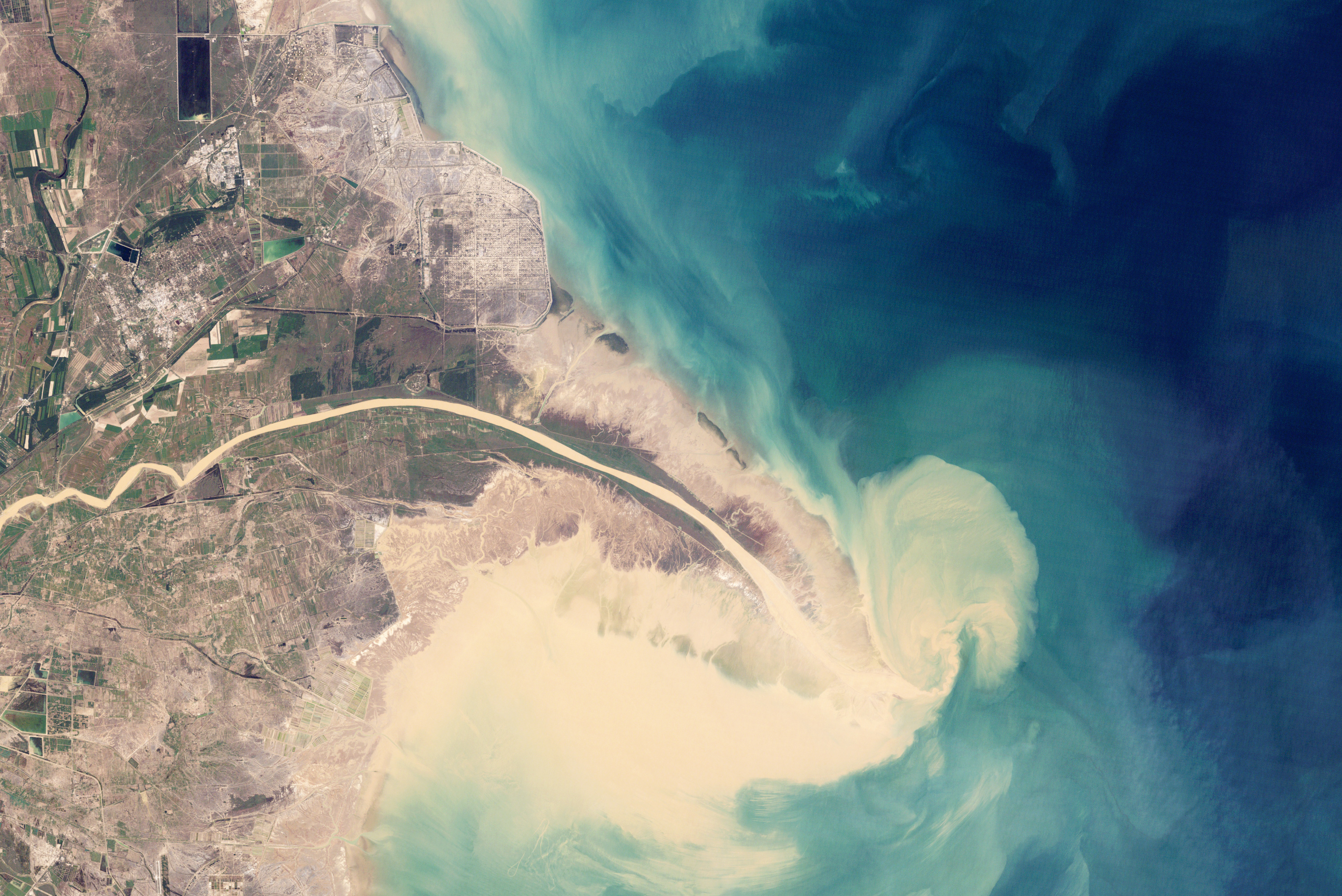
English: China’s Huang He (Yellow River) is the most sediment-filled river on Earth. Flowing northeast to the Bo Hai Sea from the Bayan Har Mountains, the Yellow River crosses a plateau blanketed with up to 300 meters (980 feet) of fine, wind-blown soil. The soil is easily eroded, and millions of tons of it are carried away by the river every year. Some of it reaches the river’s mouth, where it builds and rebuilds the delta.
The Yellow River Delta has wandered up and down several hundred kilometers of coastline over the past two thousand years. Since the mid-nineteenth century, however, the lower reaches of the river and the delta have been extensively engineered to control flooding and to protect coastal development. This sequence of natural-color images from NASA's Landsat satellites shows the delta near the present river mouth at five-year intervals from 1989 to 2009. |
| Data | |
| Šaltinis | http://earthobservatory.nasa.gov/Features/WorldOfChange/yellow_river.php?src=eoa-features |
| Autorius | NASA |
| Leidimas (Šios rinkmenos panaudojimas kitur) |
Original work of NASA - public domain |
| Kitos versijos |
|


| Šis failas licencijuojamas viešajam naudojimui, nes jis buvo sukurtas NASA. NASA autorinių teisių taisyklės nurodo, kad „NASA medžiaga nėra saugoma autorinių teisių, išskyrus pažymėtą“ (NASA autorių teisių taisylės arba JPL paveikslėlių naudojimo tvarka). | ||
 |
Įspėjimai:
|
Rinkmenos istorija
Paspauskite ant datos/laiko, kad pamatytumėte rinkmeną tokią, kokia ji buvo tuo metu.
| Data/Laikas | Miniatiūra | Matmenys | Naudotojas | Paaiškinimas | |
|---|---|---|---|---|---|
| dabartinis | 19:49, 1 vasario 2010 | | 3 001 × 2 004 (3,18 MiB) | Captain-tucker | {{Information |Description={{en|China’s Huang He (Yellow River) is the most sediment-filled river on Earth. Flowing northeast to the Bo Hai Sea from the Bayan Har Mountains, the Yellow River crosses a plateau blanketed with up to 300 meters (980 feet) o |
Paveikslėlio naudojimas
Paveikslėlis yra naudojamas šiuose puslapiuose:
Visuotinis rinkmenos naudojimas
Ši rinkmena naudojama šiose viki svetainėse:
- Naudojama bat-smg.wikipedia.org
- Naudojama ca.wikipedia.org
- Naudojama he.wikipedia.org
- Naudojama pl.wikipedia.org
- Naudojama sv.wikipedia.org