
Vaizdas:Wells Europe 4th ice age.png

Šios peržiūros dydis: 800 × 583 taškų. Kitos 5 rezoliucijos: 320 × 233 taškų | 640 × 466 taškų | 1 024 × 746 taškų | 1 280 × 933 taškų | 1 608 × 1 172 taškų.
Didesnės raiškos iliustracija (1 608 × 1 172 taškų, rinkmenos dydis: 66 KiB, MIME tipas: image/png)
| Ši byla yra iš bendros Wikimedia Commons nemokamų resursų duomenų bazės, palaikomos Wikimedia Foundation organizacijos. Norėdami sužinoti licencijavimo smulkmenas, žiūrėkite paveikslėlio aprašymą |  |
Į paveikslėlio aprašymą |
Aprašymas
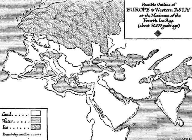
| Aprašymas | (in 1920) "THIS MAP REPRESENTS THE PRESENT STATE OF OUR KNOWLEDGE OF THE GEOGRAPHY OF EUROPE AND WESTERN ASIA AT A PERIOD WHICH WE GUESS TO BE ABOUT 50,000 YEARS AGO, THE NEANDERTHALER AGE. Much of this map is of course speculative, but its broad outlines must be fairly like those of the world in which men first became men." |
| Data | |
| Šaltinis | Wells, H. G. (1920). The Outline of History. Garden City, New York: Garden City Publishing Co., Inc.. |
| Autorius | H. G. Wells |
Licencija
This media file is in the public domain in the United States. This applies to U.S. works where the copyright has expired, often because its first publication occurred prior to January 1, 1929, and if not then due to lack of notice or renewal. See this page for further explanation.
|
 | |
 |
This image might not be in the public domain outside of the United States; this especially applies in the countries and areas that do not apply the rule of the shorter term for US works, such as Canada, Mainland China (not Hong Kong or Macao), Germany, Mexico, and Switzerland. The creator and year of publication are essential information and must be provided. See Wikipedia:Public domain and Wikipedia:Copyrights for more details.
|
Rinkmenos istorija
Paspauskite ant datos/laiko, kad pamatytumėte rinkmeną tokią, kokia ji buvo tuo metu.
| Data/Laikas | Miniatiūra | Matmenys | Naudotojas | Paaiškinimas | |
|---|---|---|---|---|---|
| dabartinis | 21:28, 1 vasario 2011 | | 1 608 × 1 172 (66 KiB) | Ras67 | cropped |
| 07:48, 3 birželio 2007 |  | 1 803 × 1 324 (87 KiB) | SEWilco | {{Information |Description=(in 1920) "THIS MAP REPRESENTS THE PRESENT STATE OF OUR KNOWLEDGE OF THE GEOGRAPHY OF EUROPE AND WESTERN ASIA AT A PERIOD WHICH WE GUESS TO BE ABOUT 50,000 YEARS AGO, THE NEANDERTHALER AGE. Much of this map is of course speculat |
Paveikslėlio naudojimas
Paveikslėlis yra naudojamas šiuose puslapiuose:
Visuotinis rinkmenos naudojimas
Ši rinkmena naudojama šiose viki svetainėse:
- Naudojama en.wikipedia.org
- Naudojama fr.wikipedia.org
- Naudojama hu.wikipedia.org
- Naudojama ru.wikipedia.org