
Vaizdas:Taxodium mucronatum range map.png
Šios peržiūros dydis: 795 × 600 taškų. Kitos 3 rezoliucijos: 318 × 240 taškų | 636 × 480 taškų | 908 × 685 taškų.
Didesnės raiškos iliustracija (908 × 685 taškų, rinkmenos dydis: 61 KiB, MIME tipas: image/png)
| Ši byla yra iš bendros Wikimedia Commons nemokamų resursų duomenų bazės, palaikomos Wikimedia Foundation organizacijos. Norėdami sužinoti licencijavimo smulkmenas, žiūrėkite paveikslėlio aprašymą |  |
Į paveikslėlio aprašymą |
Aprašymas
| Aprašymas |
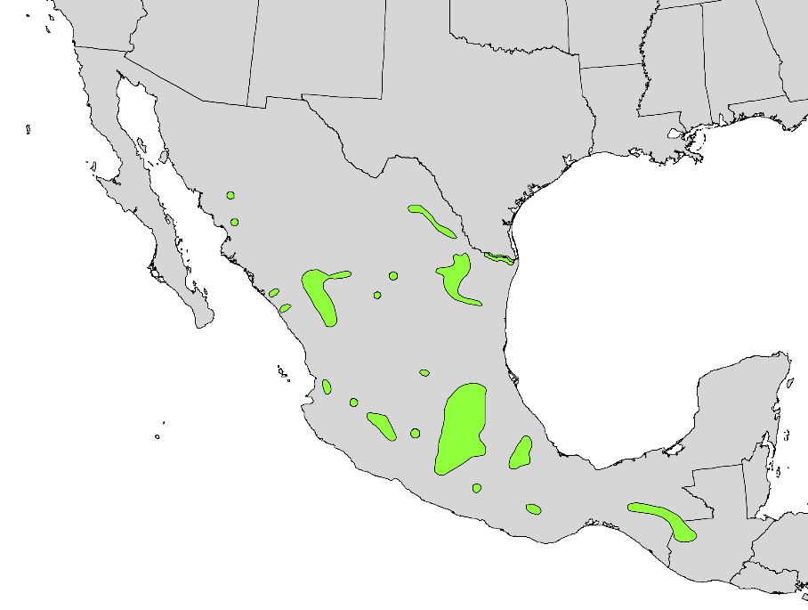
English: Range distribution map of Taxodium mucronatum — Montezuma cypress, in North America. |
|||
| Data | ||||
| Šaltinis | Digital representation of "Atlas of United States Trees" by Elbert L. Little, Jr. [1] | |||
| Autorius | U.S. Geological Survey | |||
| Leidimas (Šios rinkmenos panaudojimas kitur) |
|
Licencija
This work is in the public domain in the United States because it is a work prepared by an officer or employee of the United States Government as part of that person’s official duties under the terms of Title 17, Chapter 1, Section 105 of the US Code.
Note: This only applies to original works of the Federal Government and not to the work of any individual U.S. state, territory, commonwealth, county, municipality, or any other subdivision. This template also does not apply to postage stamp designs published by the United States Postal Service since 1978. (See § 313.6(C)(1) of Compendium of U.S. Copyright Office Practices). It also does not apply to certain US coins; see The US Mint Terms of Use.
|
 | |
| This file has been identified as being free of known restrictions under copyright law, including all related and neighboring rights. | ||
Rinkmenos istorija
Paspauskite ant datos/laiko, kad pamatytumėte rinkmeną tokią, kokia ji buvo tuo metu.
| Data/Laikas | Miniatiūra | Matmenys | Naudotojas | Paaiškinimas | |
|---|---|---|---|---|---|
| dabartinis | 03:10, 22 gruodžio 2012 | | 908 × 685 (61 KiB) | MPF | cleanup |
| 17:17, 11 spalio 2012 |  | 908 × 712 (102 KiB) | Pinethicket | {{Information |Description ={{en|1=Range map of ''Taxodium mucronatum'' }} |Source =Digital representation of "Atlas of United States Trees" by Elbert L. Little, Jr. [http://esp.cr.usgs.gov/data/atlas/little/] |Author =U.S. Geologica... |
Paveikslėlio naudojimas
Paveikslėlis yra naudojamas šiuose puslapiuose:
Visuotinis rinkmenos naudojimas
Ši rinkmena naudojama šiose viki svetainėse:
- Naudojama arz.wikipedia.org
- Naudojama bg.wikipedia.org
- Naudojama ceb.wikipedia.org
- Naudojama cs.wikipedia.org
- Naudojama en.wikipedia.org
- Naudojama eo.wikipedia.org
- Naudojama es.wikipedia.org
- Naudojama fa.wikipedia.org
- Naudojama fr.wikipedia.org
- Naudojama hu.wikipedia.org
- Naudojama is.wikipedia.org
- Naudojama it.wikipedia.org
- Naudojama ja.wikipedia.org
- Naudojama no.wikipedia.org
- Naudojama pl.wikipedia.org
- Naudojama pt.wikipedia.org
- Naudojama ru.wikipedia.org
- Naudojama sv.wikipedia.org
- Naudojama uk.wikipedia.org
- Naudojama www.wikidata.org
- Naudojama zh.wikipedia.org