
Vaizdas:PIA02696-Mars Rover Opportunity-Payson Panorama.jpg
Šios peržiūros dydis: 799 × 237 taškų. Kitos 5 rezoliucijos: 320 × 95 taškų | 640 × 190 taškų | 1 024 × 304 taškų | 1 280 × 380 taškų | 5 019 × 1 489 taškų.
Didesnės raiškos iliustracija (5 019 × 1 489 taškų, rinkmenos dydis: 3,03 MiB, MIME tipas: image/jpeg)
| Ši byla yra iš bendros Wikimedia Commons nemokamų resursų duomenų bazės, palaikomos Wikimedia Foundation organizacijos. Norėdami sužinoti licencijavimo smulkmenas, žiūrėkite paveikslėlio aprašymą |  |
Į paveikslėlio aprašymą |
Aprašymas
| Aprašymas |
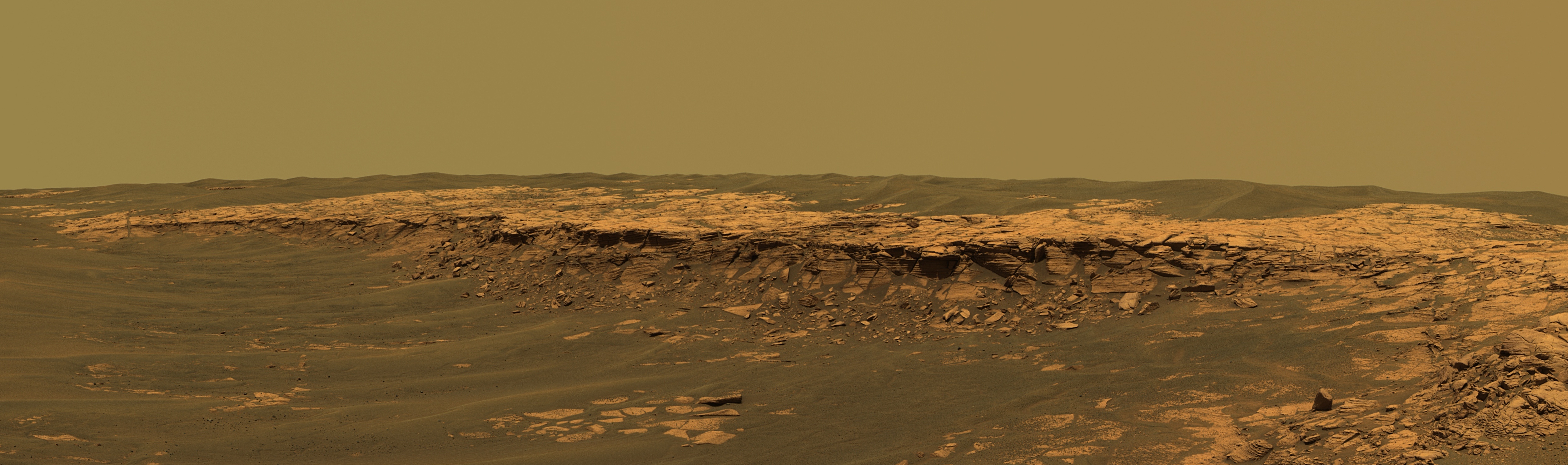
English: The panoramic camera aboard NASA's Mars Exploration Rover Opportunity acquired this panorama of the "Payson" outcrop on the western edge of "Erebus" Crater during Opportunity's sol 744 (Feb. 26, 2006). From this vicinity at the northern end of the outcrop, layered rocks are observed in the crater wall, which is about 1 meters (3.3 feet) thick. The view also shows rocks disrupted by the crater-forming impact event and subjected to erosion over time.
To the left of the outcrop, a flat, thin layer of spherule-rich soils overlies more outcrop materials. The rover is currently traveling down this "road" and observing the approximately 25-meter (82-foot) length of the outcrop prior to departing Erebus crater. The panorama camera took 28 separate exposures of this scene, using four different filters. The resulting panorama covers about 90 degrees of terrain around the rover. This approximately true-color rendering was made using the camera's 753-nanometer, 535-nanometer and 423-nanometer filters. Image-to-image seams have been eliminated from the sky portion of the mosaic to better simulate the vista a person standing on Mars would see. |
| Data | |
| Šaltinis | http://photojournal.jpl.nasa.gov/catalog/PIA02696 (TIFF converted into 95% quality JPEG) |
| Autorius | NASA/JPL-Caltech/USGS/Cornell University |
| Kitos versijos | Derivative works of this file: Payson Ridge, Erebus Crater, Mars Opportunity Rover.jpg |
This image or video was catalogued by Jet Propulsion Laboratory of the United States National Aeronautics and Space Administration (NASA) under Photo ID: PIA02696. This tag does not indicate the copyright status of the attached work. A normal copyright tag is still required. See Commons:Licensing. Other languages:
|
Licencija
| Šis failas licencijuojamas viešajam naudojimui, nes jis buvo sukurtas NASA. NASA autorinių teisių taisyklės nurodo, kad „NASA medžiaga nėra saugoma autorinių teisių, išskyrus pažymėtą“ (NASA autorių teisių taisylės arba JPL paveikslėlių naudojimo tvarka). | ||
 |
Įspėjimai:
|
Rinkmenos istorija
Paspauskite ant datos/laiko, kad pamatytumėte rinkmeną tokią, kokia ji buvo tuo metu.
| Data/Laikas | Miniatiūra | Matmenys | Naudotojas | Paaiškinimas | |
|---|---|---|---|---|---|
| dabartinis | 15:13, 27 lapkričio 2011 | 5 019 × 1 489 (3,03 MiB) | NearEMPTiness | Cropped to remove black areas | |
| 06:51, 30 rugsėjo 2006 | 5 295 × 1 950 (2,05 MiB) | Dto | {{Information |Description=The panoramic camera aboard NASA's Mars Exploration Rover Opportunity acquired this panorama of the "Payson" outcrop on the western edge of "Erebus" Crater during Opportunity's sol 744 (Feb. 26, 2006). From this vicinity at the |
Paveikslėlio naudojimas
Paveikslėlis yra naudojamas šiuose puslapiuose:
Visuotinis rinkmenos naudojimas
Ši rinkmena naudojama šiose viki svetainėse:
- Naudojama de.wikipedia.org
- Naudojama en.wikipedia.org
- Naudojama eo.wikipedia.org
- Naudojama fr.wikipedia.org
- Naudojama it.wikipedia.org
- Naudojama lb.wikipedia.org
- Naudojama no.wikipedia.org