
Vaizdas:Mars Viking 22a002.png

Šios peržiūros dydis: 800 × 156 taškų. Kitos 3 rezoliucijos: 320 × 62 taškų | 640 × 125 taškų | 2 626 × 512 taškų.
Didesnės raiškos iliustracija (2 626 × 512 taškų, rinkmenos dydis: 361 KiB, MIME tipas: image/png)
| Ši byla yra iš bendros Wikimedia Commons nemokamų resursų duomenų bazės, palaikomos Wikimedia Foundation organizacijos. Norėdami sužinoti licencijavimo smulkmenas, žiūrėkite paveikslėlio aprašymą |  |
Į paveikslėlio aprašymą |
Aprašymas
| Aprašymas |
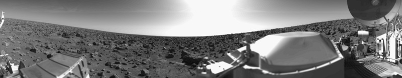
English: Original Caption Released with NASA Image: This rocky panoramic scene is the second picture of the Martian surface that was taken by Viking Lander 2 shortly after touchdown on September 3 at 3:58 PM PDT (Earth received time). The site is on a northern plain of Mars, at about 48 N. Lat., 226 W. Long., known as Utopia Planitia. The picture sweeps around 330 degrees in azimuth, starting from northwest at the left through north (above the sampler arm housing) past east, where the sky is bright at the center, and southeast toward the right above the radioisotope thermoelectric generator cover. The surface is strewn with rocks out to the horizon, ranging in size up to several meters across. Some pitted rocks resemble fragments of porous volcanic lava. Other rocks have grooves that may have been eroded by windblown sand and dust. Although fine-grained material is seen between the boulders, no sand dunes are evident. The dip in the eastern horizon at the center is an illusion caused by an 8-degree tilt of the Lander toward the west. Actually, the terrain is more level than that at the Viking 1 site. The horizon toward the left of the panorama (northwest) appears featureless, indicating that it may be several kilometers distant. The sky at the center (east) is bright because the sun was above but out of the picture at 10 AM Mars time. Toward the right (southeast), the rocks that are silhouetted against the skyline indicate that the horizon is much nearer, probably because of a slight rise in that area of the terrain. The circular high-gain antenna at the right has clots of fine-grained material adhering to the lower half, some of which appeared to have been sliding downward while the camera was scanning the area. At the extreme right, the banded appearance resulted because the camera continued to scan while it was no longer moving in azimuth. Any motion or other variation in the scene would show up as a change in successive lines. |
| Data | 2010-02-17; original photo was taken 1977-09-03. |
| Šaltinis | Own work based on images in the NASA Viking image archive |
| Autorius | "Roel van der Hoorn (Van der Hoorn)" |
| Leidimas (Šios rinkmenos panaudojimas kitur) |
I used the original 22a002.sur image from the NASA Viking image archive, converted it to .png and manually removed the noise. Except for the conversion, this was done in Adobe Photoshop CS2 and Adobe Photoshop CS4. The original file by NASA is in the public domain, and so is this new one. |
| Kitos versijos | I created this image as a replacement for the File:Vl2.jpg. This file was created by NASA, but the quality is not very high, especially on the right side. Using the original pictures from the Lander archive resulted in a higher quality image. |
Licencija
| Šis darbas buvo paskelbtas viešajam naudojimui darbo autoriaus Van der Hoorn iš anglų kalbos Vikipedija. Tai galioja visame pasaulyje. Kai kuriose šalyse tai negali būti legaliai leidžiama; jei taip: Van der Hoorn suteikia teisę naudoti šį darbą bet kokiai paskirčiai, be jokių sąlygų, nebent jos reikalaujamos įstatymų. |
The image is based on an original image from NASA to which the following copyright statement is applicable:
| Šis failas licencijuojamas viešajam naudojimui, nes jis buvo sukurtas NASA. NASA autorinių teisių taisyklės nurodo, kad „NASA medžiaga nėra saugoma autorinių teisių, išskyrus pažymėtą“ (NASA autorių teisių taisylės arba JPL paveikslėlių naudojimo tvarka). | ||
 |
Įspėjimai:
|
Rinkmenos istorija
Paspauskite ant datos/laiko, kad pamatytumėte rinkmeną tokią, kokia ji buvo tuo metu.
| Data/Laikas | Miniatiūra | Matmenys | Naudotojas | Paaiškinimas | |
|---|---|---|---|---|---|
| dabartinis | 03:31, 17 vasario 2010 | 2 626 × 512 (361 KiB) | Van der Hoorn | {{Information |Description={{en|1='''Original Caption Released with NASA Image:'''<br />This rocky panoramic scene is the second picture of the Martian surface that was taken by Viking Lander 2 shortly after touchdown on September 3 at 3:58 PM PDT (Earth |
Paveikslėlio naudojimas
Paveikslėlis yra naudojamas šiuose puslapiuose:
Visuotinis rinkmenos naudojimas
Ši rinkmena naudojama šiose viki svetainėse:
- Naudojama ca.wikipedia.org
- Naudojama de.wikipedia.org
- Naudojama en.wikipedia.org
- Naudojama es.wikipedia.org
- Naudojama fr.wikipedia.org
- Naudojama he.wikipedia.org
- Naudojama it.wikipedia.org
- Naudojama ja.wikipedia.org
- Naudojama kk.wikipedia.org
- Naudojama lmo.wikipedia.org
- Naudojama ru.wikipedia.org
- Naudojama uk.wikipedia.org
- Naudojama vi.wikipedia.org
- Naudojama zh.wikipedia.org