
Vaizdas:Cerros colorados res.jpg

Šios peržiūros dydis: 600 × 600 taškų. Kitos 6 rezoliucijos: 240 × 240 taškų | 480 × 480 taškų | 768 × 768 taškų | 1 024 × 1 024 taškų | 2 048 × 2 048 taškų | 5 237 × 5 237 taškų.
Didesnės raiškos iliustracija (5 237 × 5 237 taškų, rinkmenos dydis: 8,8 MiB, MIME tipas: image/jpeg)
| Ši byla yra iš bendros Wikimedia Commons nemokamų resursų duomenų bazės, palaikomos Wikimedia Foundation organizacijos. Norėdami sužinoti licencijavimo smulkmenas, žiūrėkite paveikslėlio aprašymą |  |
Į paveikslėlio aprašymą |
Aprašymas
| Aprašymas |
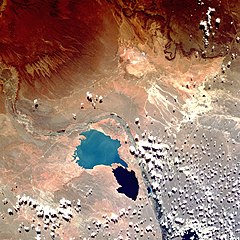
English: Shuttle image of "Cerros Colorados Complex", province of Neuquén, Argentina, March 1990
|
| Data | |
| Šaltinis | http://eol.jsc.nasa.gov/sseop/EFS/photoinfo.pl?PHOTO=STS036-80-62 |
| Autorius | Image Science & Analysis Laboratory, NASA Johnson Space Center |
| Fotografijos koordinatės | | Šis ir kiti paveikslėliai: OpenStreetMap |
|---|
This image or video was catalogued by Johnson Space Center of the United States National Aeronautics and Space Administration (NASA) under Photo ID: STS036-80-62. This tag does not indicate the copyright status of the attached work. A normal copyright tag is still required. See Commons:Licensing. Other languages:
|
Licencija
This file is in the public domain in the United States because it was created by the Image Science & Analysis Laboratory, of the NASA Johnson Space Center. NASA copyright policy states that "NASA material is not protected by copyright unless noted". (NASA media use guidelines or Conditions of Use of Astronaut Photographs).
Photo source: STS036-80-62.
|
Rinkmenos istorija
Paspauskite ant datos/laiko, kad pamatytumėte rinkmeną tokią, kokia ji buvo tuo metu.
| Data/Laikas | Miniatiūra | Matmenys | Naudotojas | Paaiškinimas | |
|---|---|---|---|---|---|
| dabartinis | 18:38, 7 rugpjūčio 2013 | | 5 237 × 5 237 (8,8 MiB) | Ras67 | high resolution |
| 21:49, 26 spalio 2007 |  | 640 × 640 (180 KiB) | Denniss | ||
| 23:16, 15 vasario 2007 |  | 600 × 600 (103 KiB) | Rosarinagazo | Shuttle image of "Cerros Colorados Complex", province of Chubut, Argentina Author: NASA http://en.wikipedia.org/wiki/Image:Cerros_colorados_res.jpg Category:Dams |
Paveikslėlio naudojimas
Paveikslėlis yra naudojamas šiuose puslapiuose:
Visuotinis rinkmenos naudojimas
Ši rinkmena naudojama šiose viki svetainėse:
- Naudojama de.wikipedia.org
- Naudojama en.wikipedia.org
- Naudojama eo.wikipedia.org
- Naudojama es.wikipedia.org
- Naudojama fr.wikipedia.org
- Naudojama gl.wikipedia.org
- Naudojama no.wikipedia.org
- Naudojama uk.wikipedia.org
- Naudojama www.wikidata.org
- Naudojama zh.wikipedia.org