
Vaizdas:Afghanistan region during 500 BC.jpg
Afghanistan_region_during_500_BC.jpg (348 × 347 taškų, rinkmenos dydis: 56 KiB, MIME tipas: image/jpeg)
| Ši byla yra iš bendros Wikimedia Commons nemokamų resursų duomenų bazės, palaikomos Wikimedia Foundation organizacijos. Norėdami sužinoti licencijavimo smulkmenas, žiūrėkite paveikslėlio aprašymą |  |
Į paveikslėlio aprašymą |
| Aprašymas |
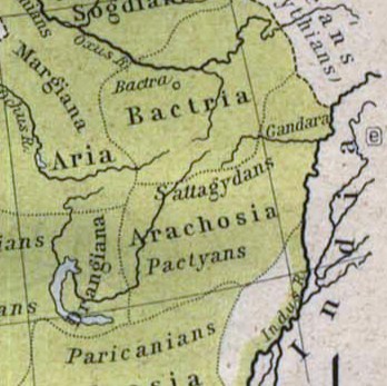
Español: Mapa histórico del Imperio Aqueménida.
English: Historic map of the Achaemenid Empire
Français : Carte historique de l'empire achéménide
Arachosia, Aria and Bactria were the ancient satraps of the Persian Achaemenid Empire that made up most of what is now Afghanistan and western Pakistan during 500 B.C. The main inhabitants of Arachosia were known as Pactyans, whose name possibly survives in today's Pakhtuns. |
||||
| Data | |||||
| Šaltinis |
http://www.lib.utexas.edu/maps/historical/history_asia.html http://www.lib.utexas.edu/maps/historical/shepherd/persian_empire.jpg |
||||
| Autorius | William R. Shepherd (b. 1871 - d. 1934) | ||||
| Leidimas (Šios rinkmenos panaudojimas kitur) |
|
||||
| Kitos versijos | File:Map of the Achaemenid Empire.jpg (full) | ||||
Rinkmenos istorija
Paspauskite ant datos/laiko, kad pamatytumėte rinkmeną tokią, kokia ji buvo tuo metu.
| Data/Laikas | Miniatiūra | Matmenys | Naudotojas | Paaiškinimas | |
|---|---|---|---|---|---|
| dabartinis | 16:48, 12 kovo 2010 | | 348 × 347 (56 KiB) | Officer | {{Information |Description={{es|Mapa histórico del imperio Aqueménido.}} {{en|Historic map of the Achaemenid Empire}} {{fr|Carte historique de l'empire achéménide}} |Source=http://www.lib.utexas.edu/maps/historical/history_asia.html http://www.lib.ut |
| 23:47, 21 sausio 2010 |  | 324 × 357 (63 KiB) | Officer | {{Information |Description={{es|Mapa histórico del imperio Aqueménido.}} {{en|Historic map of the Achaemenid Empire}} {{fr|Carte historique de l'empire achéménide}} |Source=http://www.lib.utexas.edu/maps/historical/history_asia.html http://www.lib.ut |
Paveikslėlio naudojimas
Paveikslėlis yra naudojamas šiuose puslapiuose:
Visuotinis rinkmenos naudojimas
Ši rinkmena naudojama šiose viki svetainėse:
- Naudojama am.wikipedia.org
- Naudojama ar.wikipedia.org
- Naudojama azb.wikipedia.org
- Naudojama az.wikipedia.org
- Naudojama bg.wikipedia.org
- Naudojama bn.wikipedia.org
- Naudojama ca.wikipedia.org
- Naudojama de.wikipedia.org
- Naudojama en.wikipedia.org
- Naudojama eo.wikipedia.org
- Naudojama es.wikipedia.org
- Naudojama he.wikipedia.org
- Naudojama hi.wikipedia.org
- Naudojama hr.wikipedia.org
- Naudojama hy.wikipedia.org
- Naudojama id.wikipedia.org
- Naudojama it.wikipedia.org
- Naudojama ja.wikipedia.org
- Naudojama ka.wikipedia.org
- Naudojama mn.wikipedia.org
- Naudojama pt.wikipedia.org
- Naudojama ro.wikipedia.org
- Naudojama ru.wikipedia.org
- Naudojama sh.wikipedia.org
- Naudojama sk.wikipedia.org
- Naudojama sr.wikipedia.org
- Naudojama ta.wikipedia.org
- Naudojama tg.wikipedia.org
- Naudojama uk.wikipedia.org
Žiūrėti visuotinį šios rinkmenos naudojimą.