
Vaizdas:Achia.jpg

Nėra didesnės raiškos varianto.
Achia.jpg (592 × 285 taškų, rinkmenos dydis: 82 KiB, MIME tipas: image/jpeg)
| Ši byla yra iš bendros Wikimedia Commons nemokamų resursų duomenų bazės, palaikomos Wikimedia Foundation organizacijos. Norėdami sužinoti licencijavimo smulkmenas, žiūrėkite paveikslėlio aprašymą |  |
Į paveikslėlio aprašymą |
Aprašymas
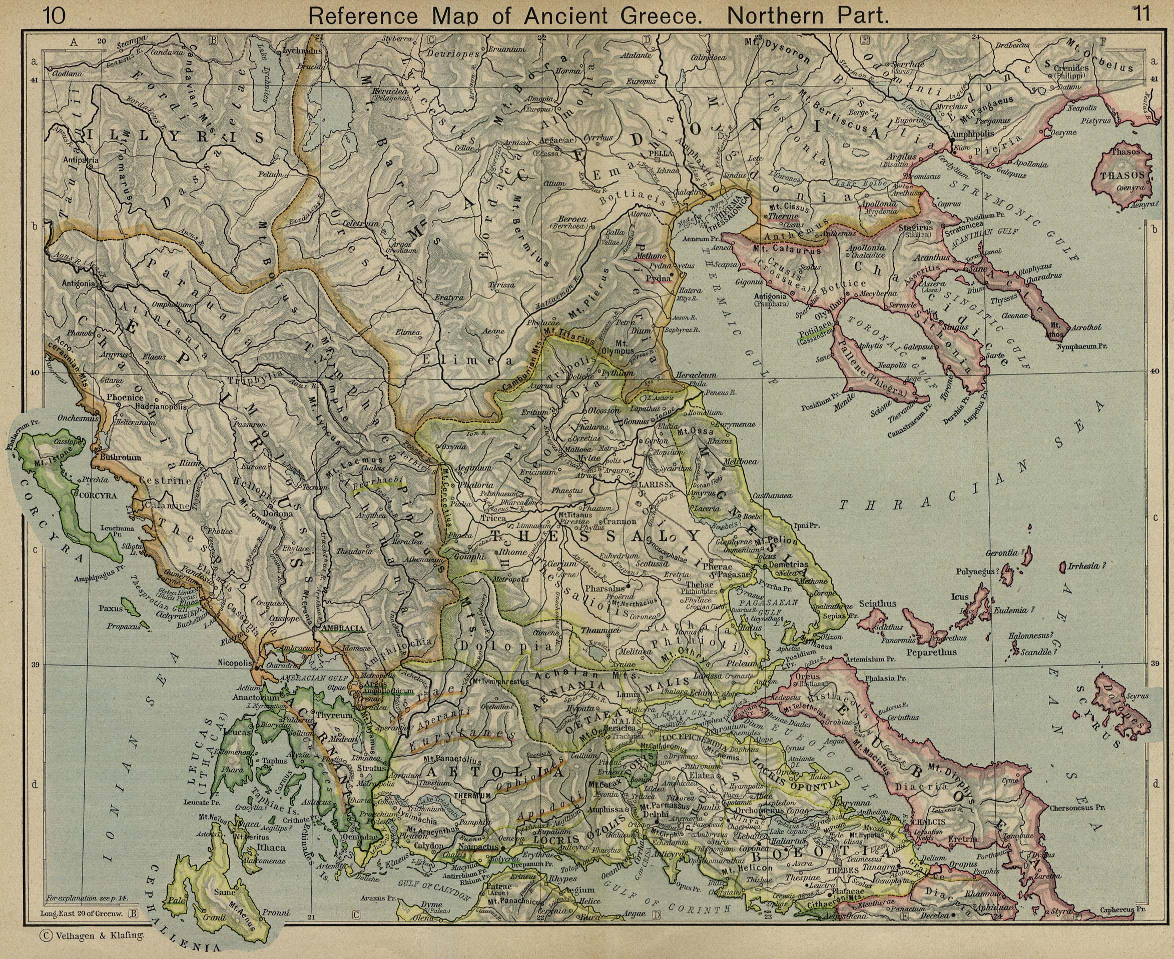
Español: Mapa de Acaya
Map of Achia, cropped from old public domain map of Greece, from the Perry-Castañeda Library Map Collection, Historical Atlas by William R. Shepherd north, south
This media file is in the public domain in the United States. This applies to U.S. works where the copyright has expired, often because its first publication occurred prior to January 1, 1929, and if not then due to lack of notice or renewal. See this page for further explanation.
|
 | |
 |
This image might not be in the public domain outside of the United States; this especially applies in the countries and areas that do not apply the rule of the shorter term for US works, such as Canada, Mainland China (not Hong Kong or Macao), Germany, Mexico, and Switzerland. The creator and year of publication are essential information and must be provided. See Wikipedia:Public domain and Wikipedia:Copyrights for more details.
|
Rinkmenos istorija
Paspauskite ant datos/laiko, kad pamatytumėte rinkmeną tokią, kokia ji buvo tuo metu.
| Data/Laikas | Miniatiūra | Matmenys | Naudotojas | Paaiškinimas | |
|---|---|---|---|---|---|
| dabartinis | 11:30, 12 gruodžio 2006 | | 592 × 285 (82 KiB) | Roke~commonswiki | Map of Achia, cropped from old public domain map of Greece, from the Perry-Castañeda Library Map Collection, Historical Atlas by William R. Shepherd [http://www.lib.utexas.edu/maps/historical/shepherd/greece_ancient_n_ref_1926.jpg north], [http://www.lib |
Paveikslėlio naudojimas
Paveikslėlis yra naudojamas šiuose puslapiuose:
Visuotinis rinkmenos naudojimas
Ši rinkmena naudojama šiose viki svetainėse:
- Naudojama als.wikipedia.org
- Naudojama ceb.wikipedia.org
- Naudojama de.wikipedia.org
- Naudojama el.wikipedia.org
- Naudojama en.wikipedia.org
- Naudojama eo.wikipedia.org
- Naudojama es.wikipedia.org
- Naudojama id.wikipedia.org
- Naudojama it.wikipedia.org
- Naudojama ja.wikipedia.org
- Naudojama la.wikipedia.org
- Naudojama lv.wikipedia.org
- Naudojama nn.wikipedia.org
- Naudojama sh.wikipedia.org
- Naudojama sr.wikipedia.org
- Naudojama vi.wikipedia.org
- Naudojama www.wikidata.org